


The Central American Probabilistic Risk Assessment (CAPRA) initiative
Introduction
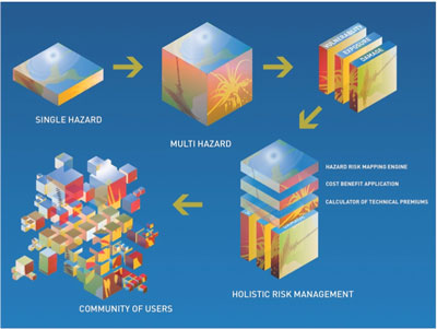
Foto: © CAPRA
The Central American Probabilistic Risk Assessment (CAPRA) initiative seeks to enhance disaster risk understanding in the Central American region. It provides a Geographic Information System (GIS)-based platform of information on natural hazard risk, for disaster risk analysis and communication. CAPRA is a tool that enables decision-makers to manage risk at local, national and regional levels.
The primary CAPRA product is a series of risk maps. The CAPRA methodology determines risk in a probabilistic manner, i.e. the intensity and frequency of occurrence of hazards over a period of time is taken into account. These risk maps present specific quantitative information on the potential losses a country, region, or particular city could face if struck by single or multiple hazards.
These visual representations of risk enable decisionmakers to adopt a comprehensive approach toward disaster risk management: with the information CAPRA provides, decisions can be made a priori about prevention, mitigation and response to natural hazards.
Led by the Central American Coordination Centre for Disaster Prevention (CEPREDENAC), in partnership with Central American governments, the CAPRA initiative is supported by the United Nations International Strategy for Disaster Reduction Secretariat (UN-ISDR), the Inter-American Development Bank (IDB), and the World Bank.
Probabilistic Risk Assessment
CAPRA applies probabilistic risk techniques to determine the intensity (severity) and the likelihood (probability) of occurrence of hazards such as hurricanes, earthquakes, landslides, volcanoes, or rainfall.
Probabilistic techniques employ the statistical analysis of historical datasets to assess potential hazard intensity, duration, and frequency across a countrys territory. This multi-hazard information is combined with data on exposure and vulnerability of assets or population to determine a spatial estimate of risk, or potential losses. Risk is expressed in terms of human impact; damage to assets; and economic and financial losses, and it is measured with probability of exceedance or frequency of occurrence parameters.
The CAPRA software therefore quantifies risk according to a rigorous methodology, providing the disaster risk community with a common language for measuring, comparing or aggregating expected losses. Using probabilistic techniques, as opposed to deterministic analysis, ensures that the inherent uncertainties associated with intensity and frequency in model estimates are incorporated, providing more accurate information necessary to manage future disaster risk.
Why use CAPRA?
CAPRA responds to a demand for increased disaster risk understanding in Central America. It is a communication tool that visually represents risk in order to facilitate decision-making at various levels and sectors.
Through the application of probabilistic modeling, CAPRA provides accurate risk information, and quantifies risk in useful metrics. Building upon the work of generations of disaster experts, CAPRA makes use of existing initiatives and provides a common language for analysis and comparison of risk.
CAPRA goes beyond focusing on one sector: it can be applied at various levels, ranging from health and education to investment and development planning. CAPRA also offers various applications (discussed below), and moves away from black box models with vendor lock in: the software architecture is open and accessible to the community.
At the core of CAPRA is the commitment to be an open and transparent information platform. At the data level CAPRA uses standard data formats established under the Open Geospatial Consortium (OGC) to build the catalogue of risk information, allowing for maximum inter-operability with existing systems. At the software level it allows users to build their own applications, using all or part of CAPRA, upon the platform, enhancing the functionality of the software.
The CAPRA initiative is embracing Web 2.0 technologies and the underlying premise of collaboration offering new ways to communicate and work together. All CAPRA hazard and risk reports are available online in a wiki form (a collaborative website set up to allow user editing and adding of content), providing a space for users to debate and pose questions about the CAPRA methodology through an online discussion forum (www.ecapra.org/wiki).
In recent years, Geographic Information Systems (GIS) have allowed the public to display and manipulate geo-referenced data through tools such as Google Earth/Maps, Virtual Earth and WorldWind Java. CAPRA is using these 3-D models to communicate ideas and collect data in new ways. To overcome the critical challenge of data collection in Central America, CAPRA is exploring new technologies, such as high resolution aerial photography, satellite imagery and crowd sourcing. An example of the use of crowd-sourcing to collect exposure data can be viewed on the wiki, in a risk assessment made for Bluefields, Nicaragua.
CAPRA applications
Once risk has been determined, decision makers can use the various CAPRA applications to address the situation and engage in a comprehensive disaster risk management approach. CAPRA applications include:
- a hazard assessment report for territorial planning
- a cost-benefit application for analysis of retrofitting projects
- a calculator of technical premiums for insurance
The CAPRA platform has the potential to assess the impact of climate change by using hazard models derived from climate, rather than historical data. For example, CAPRA could provide a risk evaluation of a climate change impact scenario using a model and future scenario projection from the Intergovernmental Panel on Climate Change (IPCC).
The CAPRA community
CAPRA users range from technical experts, academics, government institutions, and emergency response organizations, to risk management consultants and decision-makers, a wide and far-reaching community.
The CAPRA initiative is engaging universities to work with CAPRA software and collect data. Scholarships are currently being offered to post graduate students to explore the potential of the CAPRA tools within the academic sector and especially to support graduatestudent projects. The CAPRA initiative recognizes the importance of educating the current generation of professionals within the fields related to disaster risk and therefore welcomes students contributions and initiatives to expand and improve its tools and applications
CAPRA, moving away from the standard single hazard analysis approach, provides a multi-hazard risk assessment based on probabilistic modeling, and taking into account vulnerability, exposure and damage. This risk information can be applied at various levels and in different sectors including: health; education; housing; and planning. Using the CAPRA applications, decisions can be made to prevent, mitigate or respond to disaster risk. CAPRA thus provides a holistic risk management approach and creates a broad disaster risk management community.
Conclusion
CAPRA is part of an ongoing effort to promote a proactive disaster risk management strategy in the Central American region. Ultimately CAPRA hopes to contribute to Central Americas sustainable development by supporting a regional strategy that advances disaster risk evaluation and risk management decision-making across all sectors.
For further information, please contact:
Emma Phillips
ephillips@worldbank.org
| © ONU/EIRD |