The Nasa Community and Renewed Volcanic Activity at the Nevado del Huila Volcano, Tierradentro Páez Region, Cauca, Colombia
In the early hours of April 24, 2007, the “orange mountain,” the Nevado del Huila Volcano, erupted. The eruption was so strong that it partially melted the icecap and caused an enormous avalanche into the Páez and Simbola rivers, which run through lands inhabited by the Nasa indigenous community.
As long as the light of day allowed, the residents of Belalcázar (the urban center of the municipality, with a population of about 5,000) were able to observe the magnitude of the avalanche that had swept over the Páez River, carrying away the roads, bridges, crops, and animals in its path. During the first few hours, little was known about what had happened in the rural area, but when communication was restored, word arrived that the population had survived. In the midst of all the uncertainty, it was great news: no loss of human life. By putting into practice the Emergency and Contingency Plans drawn up earlier in each of the indigenous reservations, the residents had taken refuge in the highest and most secure areas to stay safe from the avalanche.
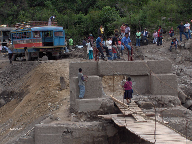
Photo: Cabildos Asosiation
But, why exactly were the indigenous communities so successful in facing an emergency situation of this magnitude? To understand this process, we must go back to February 18, 2007, when the volcano began to show the first signs of renewed activity. At that time, the 15 indigenous reservations in the municipality of Páez made a collective effort to work towards one common goal: an Emergency and Contingency Plan for the rural area. This meant hours of intense work, drawing up risk, vulnerability and mitigation (evacuation) maps. All community members participated in this process, from children to adults and elders. Using color markers and paper, they combined traditional and technical knowledge to develop maps of the existing hazards —maps that indicated the areas that could be affected by an avalanche even greater than the 1994 event along the Páez and Simbola rivers. They also prepared vulnerability maps that identified and took inventory of each “exposed element” (houses, roads, bridges, crops, population, etc.), as well as mitigation maps (identifying evacuation routes and safe areas). During this process, they made use of an essential tool: the social cartography developed by Professor Guillermo Santamaría for the collective geographic mapping of the past, present, and future, using the indigenous worldview as the basis of the process. Just one month before the April 24 avalanche, they had been in the caserío of Wila, personally witnessing the preparations being made by the Nasa community. They were there as part of an academic outing with a group of 30 students from the Universidad del Valle and with OSSO Director, Professor Velásquez. In an effort to support and contribute to the process, we developed inventories and geo-referenced the exposed elements (houses, infrastructure etc.) with GPS, accompanied by the indigenous people of the Wila reservation in the Páez river basin.
This amazing risk management process was what helped the rural population to take refuge in safer zones that they had previously identified on their maps. The “personal alarm” strategy had also worked (the innate ability of human beings, or what we call the preservation instinct). The community was continuously vigilant about the changes in the environment, having learned earlier about what kind of changes a volcanic phenomenon might cause. Equipment installed by INGEOMINAS2 to detect the mudflow in the upper Páez basin also served as an early warning system for the communities in the lower river basin.
The April 2007 event reminded us all of the June 6, 1994 avalanche, which occurred when an earthquake greater than six points on the Richter Scale caused more than 1,000 landslides in the saturated and loose soil of the steep slopes of the Páez river basin. The huge mudflow caused 1,100 deaths in the lower river basin, as well as heavy economic losses. But the 1994 event cannot really be compared with what is happening now; in many ways the two processes are totally different. The first event was produced by a specific occurrence (a strong earthquake) and the second avalanche was just the beginning of an ongoing natural process that could last days, weeks, months and even years (a volcanic phenomena). There is a tendency on the part of some institutions to equate the 1994 and 2007 events and this has led to not fully recognizing the seriousness of the current situation. This has meant that, so far, recovery efforts in the affected areas have been directed primarily at the physical aspect (reconstruction of roads, bridges etc.), but the less tangible economic, productive, social and psychological aspects have gone unnoticed and so there has been no suitable intervention. This has produced a humanitarian crisis in terms of lack of assistance for food, adequate temporary shelter, basic sanitation systems, and public health for the rural indigenous communities.
Faced with these adversities, indigenous authorities have made use of their territorial autonomy established by the 1991 National Constitution of Colombia, and on April 27, 2007, they declared a state of emergency within the indigenous territories of Tierradentro, in the municipalities of Páez and Inza, calling for the exodus of more than 2,300 Nasa families. As they put it: “…Our traditional healers are able to interpret the signs and palpitations of Earth. They have alerted their cabildos [governing councils] to leave the ancestral territory of Tierradentro. Their way of seeing and conceiving of the world through their traditional knowledge has allowed them to take this position…” in order to avoid the potential human loss that could be caused by new avalanches.
Currently, the volcanic activity is increasing as is the risk that the indigenous population will suffer from its effects. The Nasa community is aware of its capacities and limitations for facing a volcanic hazard, and so they are now preparing themselves with their own limited resources. (They have a wealth of resources from the organizational and human viewpoint, but a scarcity in terms of the basic and material goods needed for survival). Greater intervention on the part of the government would be ideal and necessary in this process. Such intervention should recognize and give credit to the work that the indigenous communities have already done since the beginning of the volcanic activity, and integrate them as active participants in developing risk management and reduction strategies, in the context of local sustainable development. In this way, they would fulfill the commitment made by all nations in the Hyogo Framework for Action, which has set as one of its five priorities: “To strengthen disaster preparedness for effective response at all levels.”
By Henry A. Peralta, Civil Engineer, Seismological Observatory of the Southwest
Research Assistant, Area of Disaster Prevention, Seismological Observatory of the Southwest, Universidad del Valle, Cali, Colombia.
1An ecologist who accompanies this community in local development processes
2INGEOMINAS (Colombian Institute of Geology and Mining)
|