Latin America and the Caribbean
|
|
| International
Strategy for Disaster Reduction Latin America and the Caribbean |
Newsletter
ISDR Inform - Latin America and the Caribbean |
 |
|
Partners in Action |
|
|
Forward
|
|
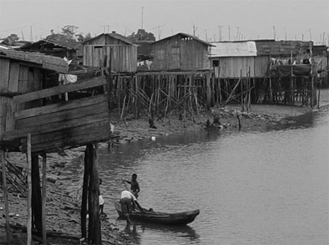
Tsunami in the Colombian Pacific: a lesson learned with the vulnerable community of Tumaco Tumaco is a municipality located in the department of Nariño, on Colombia's Pacific coast. It is part of a coastal area called "the Pearl of the Pacific," which includes part of the mainland and three islands: Tumaco, La Viciosa, and El Morro. Although the beautiful beaches and the great diversity of plant and animal species make this area attractive for tourism, its location is near the contact and subduction margin of two tectonic plates: the Nazca plate under the ocean and the South American mainland plate. The seismic history of this area shows an accumulation of a considerable number of seismic movements. Two events-one on January 31, 1906 and another on December 12, 1979-were particularly strong, bringing with them other disasters like floods, soil liquefaction, and a tsunami, or the 'big wave', as the local people call it. The events of these two dates are sealed into the memories of those inhabitants who still remember the tragedy.
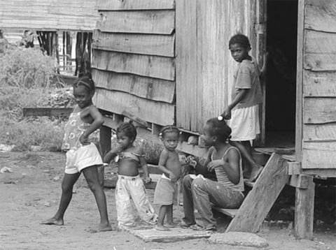
During a study of social vulnerability related to this tsunami -conducted by the Department of Geography, University of Cauca, jointly with the General Bureau for Disaster Prevention and Response of Colombia-, a vulnerability assessment was also carried out, based upon surveys, interviews and workshops on social mapping. Such aspects as population, education, culture, policy and institutional framework, related to the environment and the local economy, as well as all conditions derived from these aspects were taken into consideration. The Tumaco study used vulnerability as a differential factor to evaluate the threat of a tsunami and related events. This approach allows an analysis that focuses not only on property damage and loss of life, but also on the imbalances in and the impact on the livelihoods that are part of the daily relationships of this afro-descendent society. The study of social vulnerability vis-à-vis the tsunami considered factors such as poverty and the capacity or lack of it in local communities and governments to face and overcome a crisis. It also considered the age of the at-risk population, community and participatory organizing around risk management; and the political, economic, and institutional dynamics found in the Tumaco community environment. Social mapping, a dialogue on shared knowledge to cope with disasters One of the methodological strategies used in this research was a process that helped communities to recall, recognize, and draw the physical space that is the reference point for their vulnerability to the threat of a tsunami. Thus, the mapping was adapted to the characteristics of the process itself and became the social construction of the community directly involved with the territory and a way to recognize factors that help reduce risk. This type of mapping became a tangible life experience through a number of documents (maps, narrations, and records) with pictorial images of the human-territory relationship that generates balance or instability in each community. In this particular case, the decision was made not to provide the groups with any baseline maps. This way, instead of being limited to a traditional map scheme, they could more freely include images, life experiences, and various expressions of the world around them. Some work groups were given a map of the islands as complementary material. In this case, the image of the territory was external and could be mixed with images of the threat or security existing in the various sectors of Tumaco. The activity thus relied on conversation as the primary point of support. Once there was some spoken consensus, the various elements were distributed spatially in the drawing presented by the group. The result was a collective construction of vulnerability factors for the community in the event of tsunamis, soil liquefaction, or floods on the island.
Regarding Tumaco's urban area, the Center for Pollution Control in the Pacific (CCCP) designed different scenarios that included potential threats of tsunamis based upon three different variables: location of the seismic area, the magnitude of the tsunami and the tide level. Subsequently, a number of flood zone maps were shown, combining different levels of intensity reached by one single seismic activity (CCCP, 2002). The scenarios represented both dry and flooded areas in the event of a tsunami. Although these maps were used to determine the safest areas in each island, additional studies will be required to verify these facts. Three educational institutions participated in this study. At the Buenos Aires School, the children were able to work together to recognize some danger areas. They were not based as much on the natural characteristics of the areas-the children did not appear to have a clear understanding of these-as on certain social activities that occurred in those areas. They identified beaches as danger areas and the fishing port and the sports complex as safety areas. Bridges were considered safe because they could serve as an evacuation route, as well as parks because they could serve as temporary shelter in the event of a tsunami. These places, however, were also seen as dangerous since there are serious crime problems in these bridges and parks. In their drawings, this group of children included their houses and school as safe areas due to their high level of protection that they find in both places, regardless of their location. Their drawings reflect the relationship that these children establish between threats and social problems, and they showed a very heterogeneous concept of both danger and safety areas. At the Max Seidel National School, the social mapping was carried out as part of specialized academic courses in ocean sciences, where students have a broad understanding of tsunami-related issues. These students graphically identified the airport, parks, the lighthouse, some streets, and their school as safe areas. Unsafe areas, or places with a high level of threat, included the entire beachfront area of the islands exposed to the open sea. In all cases, areas near the school buildings were identified with greater detail. The students at Santa Teresita Girl's School had not received any special courses on risk issues, but they had participated in training workshops offered by the institutions working on local disaster prevention. They were able to identify certain reference points in terms of the characteristics of the earthquake-tsunami events. They could also identify safe and unsafe places in the Tumaco island area. It was clear, however, that there was a lack of understanding with regard to prevention and emergency preparedness. In their drawings, certain sectors were attributed a double quality. The participants may have thought about the situation endured in past events and the possibility of being safe or unsafe given a similar situation today. In general terms, their knowledge reflects the preparation processes in which they have participated, along with the possibility of complementing that information with new material. This shows a level of learning and education that could help lessen their existing level of vulnerability. This research focused on the images and expressions that community members used to depict their perception of reality in times of disasters like tsunamis. The purpose of this work was to try to get to know these images, their relationship to the real world, the processes that influence the transformation of these images and their effects on a regular basis. This experience represented an effort to understand the community's perception in order to strengthen communications media for learning, teaching, and sharing knowledge on the subject. Ultimately, the goal was to formalize communication channels to collect the results of previous local experiences of disaster prevention and management on all three islands and involve their inhabitants in a participatory process of comprehensive local risk management. For more information please contact:
|
|
|
Forward
|
| © UN/ISDR |