Mitigation of volcanic risks in the district of Alto Selva Alegre
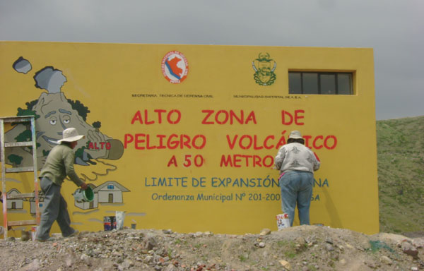
Photo: © INGEMMET
Using knowledge, innovation, and education to build a culture of safety and resilience at all levels
The Peruvian city of Arequipa has experienced rapid urban growth over the last 60 years. In 1940, the city’s population was 112,306. By 2005, it had grown to 862,747 people. The Misti crater is located just 18 km from the center of the city, whose inhabitants are unprepared for a volcanic crisis, and are unaware of the potential volcanic hazards and their impact on the environment. The district of Alto Selva Alegre, where this project is being developed, is one of the districts closest to Misti, located just 15 km from the volcano’s crater. The district has grown at an accelerated rate over the last 20 years, with little planning and without consideration of risk-management criteria, evidenced by the fact that settlements now occupy high-risk areas located in the streams along the sides of the volcano.
In recent years, and in response to a number of natural events that have caused disasters in different parts of the world, the study of geological hazards has become a priority for geological services. These studies constitute a basic foundation for developing emergency plans and land-use planning, and for implementing prevention and mitigation measures. Thanks to the support and philosophy of the Multinational Andean Program–Geosciences for the Andean Communities (MAP-GAC), the Geological, Mineral and Metallurgical Institute of Peru (INGEMMET) began developing the Misti Volcano hazard map in 2005. Later, the Project for Education, Dissemination, and Awareness-Raising about Volcanic Hazards in Alto Selva Alegre, Arequipa began in 2006. A number of institutions are participating in this program, including INGEMMET, the Multinational Andean Project, the local government of Alto Selva Alegre, the local Civil Defense Committee, leaders and residents of the Bella Esperanza and Javier Heraud settlements, the Diego Thomson Educational Institute, the National Civil Defense Institute (INDECI), the Center for Disaster Studies and Prevention (PREDES), the provincial municipality of Arequipa, the regional government of Arequipa, the national police, and representatives of the healthcare sector, among others.
Project Goals
The primary goal of the project is to disseminate and use geo-scientific knowledge, particularly as it relates to volcanic hazards, in development planning, land-use planning, and disaster prevention in the district of Alto Selva Alegre. It aims to promote greater awareness of prevention regarding natural phenomena that generate hazards, and contribute to the implementation of risk mitigation measures.
Methodology
The Misti Volcano hazard map identified various high-risk places in the urban areas of Arequipa. These areas are located along the Chili River basin and the streams of San Lazaro, Huarangal, and Pastores. The affected districts are mainly Alto Selva Alegre, Miraflores, Mariano Melgar, Paucarpata, and El Cercado.
an effort supported by the passage of a new municipal ordinance in Alto Selva Alegre (201/2007– MDASA) which was actually called upon by the local population. The authorities have defined the limits of the district’s expansion using UTM coordinates, and these limits have been signposted. A local Civil Defense Committee has been set up in the district and is working on emergency and contingency plans in case the Misti Volcano becomes active. In addition, educational materials have been developed with the local population. Recently, illegal squatters have been evicted, in accordance with the municipal ordinance.
Within the education community, in particular at the Diego Thomson School, teachers and students have learned more about the environment in which they live, and now understand that Misti is not a “dead” volcano, a mere local symbol or a tourist attraction as some thought, but that it is an active volcano that could erupt again at any moment. Thus, they have learned about volcanic hazards, prevention-related issues, the civil defense system, rescue techniques, first aid, etc. A number of institutions have participated in these trainings, including the national police and doctors from the district’s health care sector, among others. After these trainings, the students organized and formed the Prevention Club, which supports the project by disseminating what they have learned throughout the district. Two drawing contests demonstrated the students’ level of understanding about volcanic hazards, and shows that these issues are being incorporated in cross-cutting ways into their studies.
Next steps
- Distribute the hazard map to all public agencies in the city.
- Incorporate the hazard map into the city’s mid-term guiding plan.
- Pass a municipal ordinance for the entire Arequipa metropolitan area, following the example of Alto Selva Alegre.
- Organize drills for volcanic eruptions in Alto Selva Alegre.
- Create a protected area or ecological reserve in the area surrounding the Misti Volcano to ensure it remains off limits to development and settlements.
- Incorporate topics related to volcanic hazards into school curricula.
- Develop contingency plans for the entire Arequipa metropolitan area.
Luisa Macedo1, Jersy Mariño1, Roxana Amache2, Fernando Muñoz3, and Ana Arguedas4
1Geological, Mineral and Metallurgical Institute of Peru (INGEMMET). Av. Canadá 1470, San Borja, Lima, Peru: lmacedo@ingemmet.gob.pe. 2Center for Disaster Studies and Prevention (PREDES). 3 Multinational Andean Program – Geosciences for the Andean Communities (MAP-GAC) 4. National Civil Defense Institute (INDECI), Arequipa.
For further information, please contact:
Luisa Macedo Franco
Bureau of Environmental Geology and Risks, Volcanology Area
lmacedo@ingemmet.gob.pe |