
Latin America and the Caribbean
|
|
| International
Strategy for Disaster Reduction Latin America and the Caribbean |
Newsletter
ISDR Inform - Latin America and the Caribbean |
 |
|
Socios
en Acción
|
|
|
Forward
|
|
A
Seismic Warning System for the State of Oaxaca, Mexico:
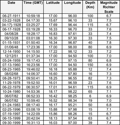
Located in the southeastern part of the Mexican Republic, the State of Oaxaca comprises 570 municipalities, over 10, 000 localities and a total population of approximately 3,438,765. The estimated area of this region is 95,364 square kilometers, in which three physiographical provinces are located. Oaxaca’s orography is uneven and its geology is considered one of the most complex ones in Mexico, due to the multiple superimposed tectonic events that take place in this area, as well as the different lithologic types that emerge. Seismic activity in Oaxaca is caused by a subduction process produced between the Cocos and North American plates, which generates both shallow and deep earthquakes between these two plates. (Table 1) Cuadro
1
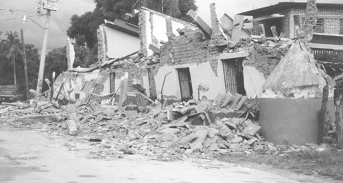
It is worth mentioning that, during the earthquakes that took place in 1999, emergency response systems were put into operation, especially after the seismic activity of September 30. Federal, state and municipal authorities, as well as society at large, the Mexican army and volunteer groups, gathered information regarding the damages caused by these earthquakes in Oaxaca, as follows: Seism of June 15, 1999. (Magnitude: 6.7° on Richter Scale). Epicenter: Tehuacan, Puebla. 177 municipalities affected: 7,505 houses, 321 schools, 167 churches, 26 hydraulic infrastructure works, and 29 municipal halls damaged. Seism of September 30, 1999. (Magnitude: 7.4° on Richter Scale). Epicenter: Puerto Escondido, Oaxaca. 508 municipalities affected: 83,498 houses, 2,698 schools, 396 churches, 123 infrastructure works, and 36 municipal halls damaged. In addition, some 450 kilometers of the federal road network were damaged as a consequence of the two aforementioned earthquakes. Along these lines, landslides equivalent to 180,000 cubic meters in volume damaged approximately 4,367 kilometers along 197 main and rural roads, causing the isolation of 333 communities.
For this reason, it is expected to install 24 field sensor stations (accelographs), aimed at detecting earthquakes and generating warning signals to be sent out to a central recording station, which will gather these data and transmit warning signals to assigned places such as schools, public offices and other crowded places. It is also expected to install relay stations with VHF or UHF broadband transmitters, in order to broadcast warnings to the population at large through radio or TV stations. This will enable us to take adequate safety measures before the occurrence of a seismic activity. Sensor stations will be installed in such way that the system for detecting seismic activities ensures that at least two stations can recognize and give warning of strong earthquakes (greater than magnitude 5). Each sensor station will transmit this information via an FM radio system with VHF or UHF frequency bands. In this manner, warnings will be broadcast through relay stations, located in strategic places so that information can be sent out to the central recording station in the city of Oaxaca. Estimated time saved between alerting of an earthquake and receiving this warning in Oaxaca is 20 seconds, given that the epicenter is located between 150 and 200 km from the city. It is expected that, once this seismic warning system is installed, the population will be provided with early warning information services, which will be translated into a number of benefits in terms of safety and decision-making processes aimed at reducing vulnerability. It is worth mentioning that this system will be linked to the one already installed in Mexico City. The primary goal of this project is to mitigate the adverse effects that earthquakes cause, as well as to raise awareness among the population regarding the actual risks present in our State, in order to learn how to live and cope with them. Initially, sensor stations will have a seismic detection range between 80 and 160 km. Both the range and the seismic sensing system will be adjusted after obtaining a number of descriptive seismic accelograms in the proposed seismic region. In order to design, build and put into operation this seismic warning system in Oaxaca, a number of activities must be carried out. These actions fall into three different stages, as follows: First stage. In this
phase, parts, supplies and materials needed to build and stabilize the
equipment required by the warning system will be purchased, as well as
the equipment needed to establish the central recording station. This
includes devices needed to monitor the transmission of warnings to the
State Unit for Civil Protection, ten radio stations and one TV station.
Furthermore, basic studies will be conducted in order to determine the
most appropriate location to install eight relay stations, which are needed
to connect all of the 24 field sensor stations with the city of Oaxaca.
This stage began in September 2002 and its completion is expected by March
2003. Third stage. In this phase, studies and statistical assessments will be conducted regarding the seismic accelerations obtained during the first year of operations. This stage is needed to adjust the seismic warning system and the different coefficients found in each of these field stations. Bibliographic References:
For further
information, please contact: |
|
|
Forward
|
| © UN/ISDR |
 Currently,
information available enables us to assert that large earthquakes, particularly
in Oaxaca, show a number of special features, such as their relatively
short recurrence period, which varies between 30 and 40 years. In terms
of civil protection, and due to the existing need to mitigate the effects
caused by these natural phenomena, the first stage of a project for installing
a State seismic warning system is underway. This system will provide information
prior to the occurrence of a seismic activity, especially in terms of
their magnitude, which may cause risks in coastal areas and the Tehuantepec
Isthmus. This is particularly relevant because, given their high seismic
potential, major earthquakes take place in these areas.
Currently,
information available enables us to assert that large earthquakes, particularly
in Oaxaca, show a number of special features, such as their relatively
short recurrence period, which varies between 30 and 40 years. In terms
of civil protection, and due to the existing need to mitigate the effects
caused by these natural phenomena, the first stage of a project for installing
a State seismic warning system is underway. This system will provide information
prior to the occurrence of a seismic activity, especially in terms of
their magnitude, which may cause risks in coastal areas and the Tehuantepec
Isthmus. This is particularly relevant because, given their high seismic
potential, major earthquakes take place in these areas.