Latin America and the Caribbean
|
|
| International
Strategy for Disaster Reduction Latin America and the Caribbean |
Newsletter
ISDR Inform - Latin America and the Caribbean |
 |
|
Contributions
|
|
|
Forward
|
|
Seismic
Prevention and Urban Development [1]
Earthquake forecasting is still largely incapable of providing early warning. In cities at high risk from seismic activity, therefore, prevention needs to be a continuing process—indeed, it must be part of a broader urban development strategy. From the point of view of urban policy, seismic activity is an inescapable condition of the natural environment, which must be contemplated at all levels of urban planning and design for the harmonious, sustainable growth of towns and cities. The case study that is here described deals with the city of San Juan, capital of the Argentinean province of the same name, located in an arid region of the mid-west of the country, at the eastern border of the Andes. This area is the most seismically active of Argentina. Numerous destructive earthquakes have been recorded over the past century, include the earthquake of 15 January 1944, which killed 10,000 people (10% of the population), practically razed the city, and affected the entire province. The city was rebuilt and now has some 400,000 inhabitants and approximately 90,000 housing units, of which 63% are seismic-resistant. (The same is true of 100% of institutional buildings.) That still leaves 37% of housing that is not seismic-resistant, a relatively high percentage in such an earthquake-prone area. Our research project focused on the urban core of San Juan and on completing three specific tasks:
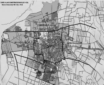
1. Maps of Probable
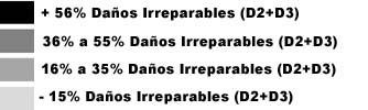
Effects of Seismic Risk The maps show the severe or irreparable damage that buildings would most likely suffer, based on three scenarios of different seismic intensity. They should prove valuable as tools for urban planning in seismic areas, particularly with regard to human settlements, infrastructure, productive activities, and emergency response measures. In order to produce the maps, the following definition of seismic risk was employed: “…The probability of occurrence and the relative degree of severity, within a given period of time, of the set of possible effects produced by an earthquake.” It can also be understood as “the probability of losses caused by seismic action.”[3] In order to measure the risk to which the population is subject in the various parts of the city, an quantitative and qualitative assessment was made of the effects that would be caused by a seismic event of intensities IX, VIII, and VII M.M—particularly the damage to seismic-resistant (SR) and non-seismic-resistant (NSR) housing. Seismic events do not have a uniform impact throughout a city. It is assumed that a building can suffer four degrees of damage, namely:
The sum of D2 and D3 damages is what is known as irreparable damage.
The seismic risk maps
were produced for the entire urban core of the city of San Juan, based
on the percentage of severe or irreparable damage that might affect housing
units should seismic events of the three intensities mentioned above ever
take place. Figure
1 Map of Probable Effects of Seismic Risk,
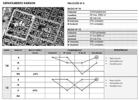
2. Acceptable Levels of Direct Vulnerability Vulnerability refers to the propensity of people, goods and activities to suffer damage or adverse changes in the event of an earthquake of significant intensity. The concept of vulnerability is eminently a question of interrelationships. It can either be direct vulnerability, which links a population to physical elements of the internal structure of a city, or functional vulnerability, which involves the relationship between people and their activities. In order to assess the acceptable levels of vulnerability, a matrix was produced involving a diagram that shows the quotient of direct vulnerability, striving for an equilibrium in the conditions of the elements that make up this quotient, without pretending to annul it. This made it possible to obtain a set of proposals that are meant to serve as inputs for the formal definition of urban management guidelines, a stage that must precede the development of urban intervention strategies. 3.Urban Intervention Strategies Those parts of the
city that suffer from significant physical or functional degradation of
their buildings, and require an intervention to revert this situation
in the short term, are considered priority areas. In defining which strategies
to apply, one must first carry out an assessment of each neighbourhood. Based on the seismic risk maps and the direct vulnerability assessments, the following strategies were drawn up:
In order to define the strategy to be followed in each of the chosen urban sectors, the direct vulnerability matrix diagram was taken into account, as well as the availability of vacant properties of more than 2,500m2 within city limits. The selected strategies for each sector have been compiled in individual cards, such as the one in Figure 2.
Given the impossibility of predicting an earthquake with any degree of practical specificity, prevention remains the best tool for mitigating its destructive effects. Sustained actions based of a firm prevention policy are economically less costly than the losses caused by an earthquake. This means that applying preventive measures at every scale of urban planning is an effective way of confronting the consequences of a future destructive seismic event. Figure 2: Urban Intervention Strategy Card
Disasters such as earthquakes not only affect the poor much more severely than anyone else, they often aggravate their poverty while driving others below the poverty line. The likely irreparable damages identified in the risk maps imply, among other things, that the most risk-prone areas would see a sudden and significant increase in the number of the homeless. The maps therefore make it possible to forecast which neighbourhoods will likely require shelters after a seismic emergency, as well as open spaces, which may be used for recreational purposes during normal times, for setting up tents or field hospitals. The maps also can serve as the basis for road and lifeline design that guarantees prompt operative access for relief workers into those areas. Urban vulnerability assessments can provide a detailed diagnosis of the seismic conditions of a city and the problems it may face as a result of an earthquake. The concept of seismic vulnerability employed in this paper is directly linked to the notion of urban development. According to this conception, vulnerability is inherently a question of the relationship between the population and certain activities or physical elements of the urban structure. Based on such assessments, it is possible to take additional steps to define specific steps to confront, within a reasonable period, the dangers present in those urban areas that suffer from a significant degree of physical or functional degradation. The urban impact of an earthquake, involving loss of life and property and the upheaval of all urban functions, makes it imperative to take seismic risk into consideration in all urban planning and development initiatives. An earthquake can also cause a variety of conflicts, as resources such as housing and even food become suddenly scarce. If one looks at a city as a system, an urban system, all of its components—people, structures and activities—can be affected by an earthquake. The problems that arise cannot be solved separately, in piecemeal fashion, but in a holistic, integrated manner. For more information,
please contact: References
1
This article summarizes the most significant aspects of “La prevención
sísmica como proyecto continuo de desarrollo urbano”, a research
paper produced by the Office of Urban Research (GIUR) of the Faculty of
Architecture, Urban Development and Design of the Universidad Nacional
de San Juan, Argentina (1997-1998). The result of a research project,
it has so far not been applied, but it has served as input for other research
projects. |
|
|
Forward
|
| © UN/ISDR |