Latin America and the Caribbean
|
|
| International
Strategy for Disaster Reduction Latin America and the Caribbean |
Newsletter
ISDR Inform - Latin America and the Caribbean |
 |
|
Contributions
|
|
|
Forward
|
|
Significance
Of An Earthquake Early Warning System For Vulnerable Essential Facilities:
The Example of A Potential Implementation in Costa Rica
A mature seismic gap
exists under and off the Nicoya peninsula on the Pacific coast of northwestern
Costa Rica. This gap, the Nicoya seismic gap, is a subduction segment
of the Middle American Trench where the Cocos plate subducts under the
Caribbean plate. Large earthquakes have occurred in this segment in 1853,
1900 and 1950. The distribution of aftershocks of large earthquakes in
the segments adjacent to the gap, during the 1990s, has made it possible
to map its geographic location and estimate its size. Without significant
slip since 1950, a convergence rate of around 88 mm/yr, and an area ranging
from 5,000 to 10,000 km2, the Nicoya gap has the potential to generate
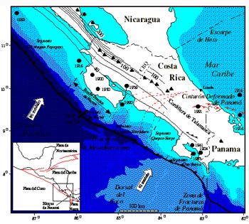
an earthquake with moment magnitude above 7.5. Many countries in Latin America have implemented programs for identifying and retrofitting seismically vulnerable essential facilities. Given the attendant costs, it is practically impossible to reinforce—or, alternatively, to demolish—all these structures before the next earthquake strikes. Costa Rica has a good seismic building code. Even so, the occurrence in the 1990s of several large-magnitude earthquakes weakened many structures, some of which might suffer significant structural damage or even collapse during the next major earthquake or its aftershocks. If we could rely on a system that, at the time an earthquake starts, could warn the occupants of these vulnerable buildings, we could reduce the number of the injured and possibly even save a considerable number of lives. Even a few seconds might be enough for the occupants to move towards more resistant areas of each building and, in some cases, to evacuate the structure altogether in an orderly manner. (This would obviously require that more resistant areas of buildings be identified in advance, disaster response plans be in place, and drills be executed.) Since, in Costa Rica, major earthquakes do not only affect the Pacific Northwest alone, the installation of more sensors along the entire coast would make it possible to warn the Central Valley of practically every event of significant magnitude occurring along the subduction zone. Tectonic Setting Central America’s tectonics are mainly controlled by the clash of the Cocos and Caribbean plates (see Figure 1). As a result of this clash, the Cocos oceanic plate is subducting under the Caribbean plate along the Middle America Trench at speeds that range from 70 mm/yr in front of Guatemala to little more than 90 mm/yr in front of the Osa peninsula [Protti, 1994, estimated from De Mets et al., 1990] (see Figure 2). It is along this plate boundary where most of the large-magnitude earthquakes occur in Costa Rica. In the southwestern boundary of the Caribbean plate, local tectonic strains have caused it to fracture and create a microplate, known as the Panama block, the boundaries of which have not yet been identified very clearly. The northern boundary of the Panama block with the Caribbean plate is a convergent margin known as the North Panama Deformed Belt [Silver et al., 1990], which ranges from the Caribbean coast of Colombia to Limon in Costa Rica (see Figures 1 and 2). It was at the western extreme point of this boundary that the Limon Earthquake of 1991 took place. Towards the Northwest, the boundary between the Panama block and the Caribbean plate is a diffuse zone of left-lateral strike-slip faulting that runs from Limon to the Middle America Trench through the central part of Costa Rica [Ponce and Case, 1987; Jacob and Pacheco, 1991; Güendel and Pacheco, 1992; Goes et al, 1993; Fan et al., 1993; Marshall et al., 1993; Fisher et al., 1994; Protti and Schwartz, 1994]. The Panama block therefore comprises the southern part of Costa Rica and all of Panama.
South of the Burica peninsula is the Panama fracture zone. This system of right-lateral strike-slip faulting is the boundary between the Cocos and Nazca plates. West of the Panama fracture zone is the Cocos Ridge, which subducts under the Osa peninsula. The Cocos Ridge is the scar caused on the Cocos plate by the Galapagos hotspot. This tectonic environment makes Costa Rica a very seismically active area, with seismic sources of different origins and depths that are spread throughout the entire country. Since April 1984, the Volcanological and Seismological Observatory of Costa Rica, National University (OVSICORI-UNA), has been recording activity from all these seismic sources and located more than 50,000 events in nearly 15 years.
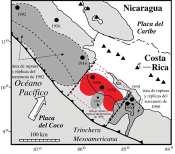
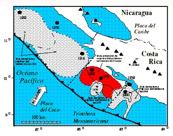
Out of all these seismic sources, the Pacific coast subduction zone is the most active both in terms of the number and the magnitude of events. The distance from these sources to the Central Valley makes early-warning systems not only feasible but also quite likely to operate successfully. Definition of the Problem Seismic gaps have been defined as those segments of active plate boundaries that have not experienced a large-magnitude seismic event in several decades and are therefore considered likely sites for future earthquakes [Nishenko, 1985]. Seismic gaps represent, therefore, a space and time gap that has not experienced the release of large amounts of seismic energy. The fact that no significant
earthquake has taken place in the Nicoya segment since October 1950, and
the occurrence of quakes first in 1990 in front of the Nicoya Gulf to
the Southeast, and later in 1992 in front of Nicaragua to the Northwest,
have made it possible to identify the temporal and geographic extension
of what Protti et al. [2001] have defined as the Nicoya seismic gap. Both
the magnitude of the previous events along this segment and the anomalously
low seismic activity during the interseismic period provide additional
information about the characteristics of a future earthquake under the
Nicoya peninsula. Large-magnitude earthquakes have taken place along the
Nicoya segment in 1853(?), 1900 and 1950. This gives us a recurrence period
of between 48 years, to 1997, and 50.7 years to 2005, with standard deviations
of 1.73 and 4.04 respectively.
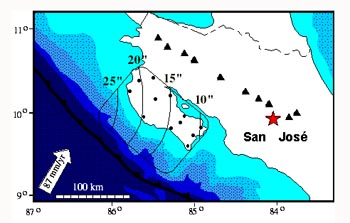
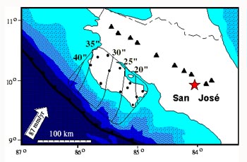
Earthquake early-warning systems take advantage of the difference between the speed of the seismic waves (3-7 km/s) and the speed of radio waves (close to the speed of light, i.e., ~300,000 km/s). At the time an earthquake occurs and is detected, it is possible to send a signal to places where it will be received much sooner than the seismic waves. The time interval between the arrival of the radio waves and the arrival of the seismic waves will be larger the closer to the epicenter the sensor is and the further away the radio receptor is from the epicenter. The system is composed of a network of strong-motion instruments (accelerometers) around the seismic source, wireless communications devices that transmit the signal to a control center, an event identification and quantification algorithm, and a radio transmitter that sends a warning signal if it should turn out to be a significant event. The event identification algorithm can be install as part of the recording network in the field, or in the control center itself. A necessary condition for an alarm to be triggered is for more than one station to detect and declare the event. This redundancy is necessary to reduce the number of false alarms as a result of local noises, electronic problems, or interference with the transmission of information. For any early-warning system to be efficient, it is strictly necessary for the population to be thoroughly trained so that it knows how to respond in the event of an alarm. Even before the early-warning system is installed, each step that needs to be taken upon reception of the alarm must be identified and repeatedly practiced. This calls for drills and the development of routines whereby both people and automated systems can learn to identify the alarm. The effective response of the population to an event—even to false alarms—is the single most significant component of the entire early-warning system. Earthquake early-warning systems are in operation and have proven effective in several countries. Examples involving tectonic conditions similar to Costa Rica’s (active subduction zones) include Mexico [Espinosa Aranda et al., 1995], Japan [Nakamura, 1985] and Taiwan [Lee et al., 1995]. It is not always possible to tell where a significant earthquake will occur, and in many cases they take place at sea, where it is quite difficult to set up seismic sensors. Moreover, even though at very large distances (>600 km) the warning interval is much larger (>2 minutes), the attenuation of the seismic waves over such distances implies that their arrival will not produce major damage. In Costa Rica, we know of a seismic source under the Nicoya peninsula with the potential to produce earthquakes of a significant magnitude [Protti et al., 2001]. The location of this seismic source enables us to place detection instruments fairly close to it, and its distance from major infrastructure and population centers enables us to provide a warning aimed at places where the seismic energy has not yet become very attenuated and significant damage may therefore occur. In addition to this seismic source, the entire Pacific region of Costa Rica has historically experienced significant earthquakes as a result of the subduction process, and its proximity to the Central Valley makes it possible for early-warning systems to be implemented with a high probability of success. What is proposed here is an early-warning system that sets off an alarm in the Central Valley several seconds before the arrival of the seismic waves generated by an earthquake in the Pacific region of Costa Rica. In the case of the Nicoya seismic gap, for instance, this system would be based on a network of 12 accelerometers distributed no more than 40 km apart from each other along the entire Peninsula (the black dots on Figures 4 and 5) [Protti et al., 1998].
The accelerometers would be sending their records in real time to the control center in the OVSICORI-UNA facilities in Heredia. There, an event identification algorithm would process the signal of each station separately to determine its magnitude based on the growth rate of the event. If the conditions for a strong event are met by more than one station, the system would set off the alarm, which would be transmitted by radio waves throughout the Central Valley and could be received by conventional receivers. These pager-like devices could be acquired by schools, public and private firms and institutions, the media, and any individual who might chose to purchase one.
The interval between the instant the alarm goes off and the time when the seismic waves arrive depends on the place where the rupture starts and the place that receives the alarm. Thus, the closer to the peninsula the alarm signal is received, the smaller the interval. Figures 4 and 5 show the results of modeling the time intervals between the detection of the earthquake by two field stations and the arrival of P and S seismic waves, respectively, to the city of San José. These time intervals have been drawn based on where the rupture would take place in a future earthquake occurring at the Nicoya seismic gap. In order to know how much time would really be available between the setting off of the alarm and the arrival of the earthquake, it would be necessary to subtract from these values the time required for the event identification algorithm to complete its routines. Mexico’s experience has been that this interval is in the order of five seconds, and could diminish if faster processors and more effective algorithms are brought to bear. For more information,
please contact: Sources
|
|
|
Forward
|
| © UN/ISDR |
 In
developing countries, so many essential facilities are vulnerable to earthquakes
that it is practically impossible to retrofit them all before the occurrence
of another event. For this reason, a system that can warn the occupants
of non-reinforced vulnerable structures a few seconds before the arrival
of seismic waves could save many lives.
In
developing countries, so many essential facilities are vulnerable to earthquakes
that it is practically impossible to retrofit them all before the occurrence
of another event. For this reason, a system that can warn the occupants
of non-reinforced vulnerable structures a few seconds before the arrival
of seismic waves could save many lives.