Latin America and the Caribbean
|
|
| International
Strategy for Disaster Reduction Latin America and the Caribbean |
Newsletter
ISDR Inform - Latin America and the Caribbean |
 |
|
Contributions
|
|
|
Forward
|
|
Arancibia
landslide-debris avalanche in Costa Rica: Since 1988 the area of Las Lagunas de Arancibia was identified as a very dangerous site, prone to develop a mayor catastrophe. During that time, the transit of Hurricane Gilbert across the Caribbean gave place to a considerable amount of translational slides and debris flows. The nearness of a bigger slide was perceived and competent authorities were advised to take the proper mitigation measures. Nevertheless, the message did not see through, and in 1993 after a period of heavy rainfall, a 2.9 millions of cubic meters translational slide was triggered, covering an area of 17.7 Ha with a debris avalanche and killing six persons. After this event, the inhabitants of the mostly affected area were evacuated, but they were still working on the cultivation fields close to the unstable slope. On July the 28th of 2000, after other period of heavy rainfall, the slide developed a new rupture, mobilizing 8.5 millions of m3, covering with a debris avalanche 78.7 Ha and killing eight persons. This is a very good example of the size of the events that the population of this country could face and of the lack of competence of the authorities to manage the prevention of natural disasters.
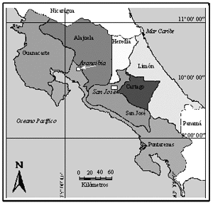
Introduction The area, were this study has been done, is located 120 km to the north-west direction from San Jose, the capital of Costa Rica. The village of Las Lagunas de Arancibia is located at an elevation of 1200 m.a.m.s.l. (Fig.1), on an area were outcrops of Monteverde Formation have been described by Chaves & Sáenz (1974). The Monteverde Formation is mainly made of an intercalation of andesitic lavas and tuffs of Pliocene age; it can reach 210 m thick and 120 km2 of surface area (Chaves & Sáenz, 1974). The Arancibia landslide had occurred on a very steep scarp, located at the edge of the lava plateau.
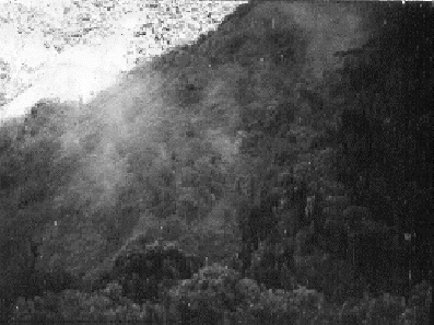
During the second part of September 1988 a considerable amount of shallow landslides and debris flows were triggered on the upper part of Aranjuez river basin, due to the heavy rains induced by Hurricane Gilbert passing across the Caribbean Sea (Mora & Rojas, 1988). Landslides affected several villages, and some families were evacuated to safer places until the emergency had declined. Local people were speculating about the possibility of a volcano to develop in the region, and some of them also heard some underground sounds and saw smoke columns. Actually, the sounds were the landslides at the moment of being triggered and the smoke was the dust generated by the rocks being crushed during their travel down hill (fig. 2).
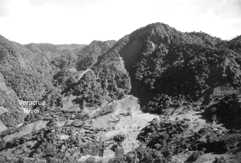
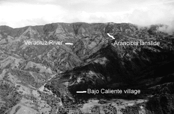
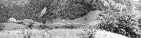
Mora & Rojas (1988) mapped some of the landslides on the region, trying to depict only the mapeable slides, because the amount was extraordinary. Even though, considering only the main slides, the slided area was 158.6 Ha. I remember when I went back from Arancibia, I glanced back to the Las Lagunas village and I thought, “this stuff is going to fall down...” Bajo Caliente is a village located where the Veracruz River joins Aranjuez River with a population that rounds 300 people. Considering that this village is located 4 m above the bottom of Aranjuez riverbed and having this river a very mismanaged upper catchment, the hazard of an avalanche that could affect the village was a major concern. Among the recommendations made to the autorities by Mora & Rojas (1988) were the necessity of evacuating Las Lagunas village and the relocation of Bajo Caliente village. They also suggested starting with a management plan of the upper Aranjuez river basin, considering the use of the land according to its aptitude. The 1993´s event After 1988 the authorities took no action, people continued to live and work on the land in Las Lagunas de Arancibia. In October the 30th 1993 at noon, a translational slide of 2.9 millions of m3 was triggered and its debris avalanche covered an area of 17.7 Ha (Fig. 3). The run out length of the avalanche was 850 m (Fig. 3). The slide was preceded by a period of intense rainfall, but when the material moved down, the rain had stopped 12 hours before.
The avalanche went down following two paths, one path followed El Silencio creek until Veracruz river, the second one partially covered Las Lagunas village, killing 6 people, destroying 2 houses, 1 building for social activities and the soccer field. The Veracruz River was not obstructed; it transported the material to the lower parts of the watershed (Fig. 4).
Esquivel & Mora (1993) were very clear: “considering the topography where the village is located, its location with respect to landslide and avalanche sources, and the geologic evidence of previous destructive events, the population of the village should be moved to a safer place”. Six sites were inspected and the proper recommendations were transmitted to the authorities, then they were encouraged to relocate the village. Bajo Caliente was once again identified as a very exposed site and recommendations tending to relocate the village were submitted to the authorities (Esquivel & Mora, 1993). Two sites were suggested as save and proper to move the population and their facilities (Esquivel & Mora, 1993).
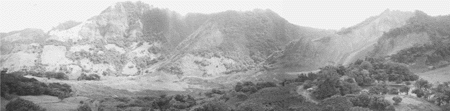
On June 27th 2000, after three days of heavy rainfall, Arancibia landslide newly started to have activity. A huge slide of 8.5 E06 m3 was triggered, then forming an avalanche that covered 78.8 Ha of cultivation fields and killing eight persons (Fig. 5). The avalanche reached a distance of 2.7 km, filling up Veracruz River canyon with debris of 60-70 m thick, on a span of 1.1 km (Fig. 6). The total volume of the slide, taking into account the events of 1993 and 2000, reached 11.4E06 m3. The total number of fatalities associated to this landslide is fourteen.
Since 1988 Las Lagunas de Arancibia village was identified as an area susceptible to be buried by an avalanche, also Bajo Caliente as a village very prone to be affected by landslides and debris flows. Despite this anticipated warning, authorities didn’t take proper actions and in 1993 the first catastrophic event was triggered, killing six people. After that, the authorities decided to evacuate the population but giving chance to cultivate their fields at the toe of the slide. On June 27th of 2000, a huge slide buried the village, killing another eight people. There are two points
to take into account in this case. First, the authorities didn’t
consider seriously the warning given by the technical advisors. This has
happened before, since the head Second, such large landslides and avalanches are not uncommon events in Costa Rica and in Central America, remember Las Casitas volcano slide and avalanche in Nicaragua, during Hurricane Mitch in 1998; so the culture of “it will never happen to me…” should be forgotten and new initiatives to prevent and mitigate the effects of natural events must be encouraged.
Chaves & Sáenz, 1974: Geología de la Cordillera de Tilarán. Ministerio de Economía Industria y Comercio, Dirección de Geología, Minas y Petróleo, Informes Técnicos y Notas Geológicas, Año 12, Bol N° 53. San José, Costa Rica. 46 p.p. Esquivel, L. & Mora, R., 1993: Informe sobre la situación del deslizamiento Laguna de Arancibia. Comisión Nacional de Emergencias, Escuela Centroamericana de Geología-UCR. Unpublished report. 4 p. Mora, R. & Rojas, W., 1988: Informe sobre los deslizamientos en la cuenca superior del río Aranjuez, Norte de Miramar. Comisión Nacional de Emergencias, Escuela Centroamericana de Geología-UCR. Unpublished report. 6 p.
|
|
|
Forward
|
| © UN/ISDR |