Latin America and the Caribbean
|
|
| International
Strategy for Disaster Reduction Latin America and the Caribbean |
Newsletter
ISDR Inform - Latin America and the Caribbean |
 |
|
Partners
in Action
|
|
|
Forward
|
|
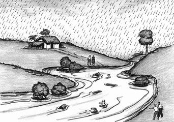
Risk and disaster management: practical and concrete elements for sustainable development During the last three years, Central America and, in particular, the mountainous regions in eastern Guatemala, have witnessed a dramatic and extreme process of environmental degradation. Although this is a slow process, year by year, it gradually intensifies the existing socioeconomic, physical and political vulnerabilities of rural populations, negatively affecting the results of current development projects. How many water supply sources have dried up during the last four years in eastern Guatemala, and how many local aqueducts have become useless, despite the fact that they have changed the lives of these communities? How many crops have wilted? All this has put at risk the availability of basic resources for their survival. But this is not the only hazard faced by this area. They also cope with hurricanes, torrential rain, earthquakes and strong winds, which cause other hazards such as floods and landslides. In this context, exposure to a hazard –regardless of how low it is-, may lead these populations to a disaster situation. Along these lines, strategies for vulnerability reduction are not sustainable if they are not integrated into risk and disaster management. Acción Contra el Hambre [Action against Hunger], with funds provided by DIPECHO (the Disaster Preparedness Program of the European Community Humanitarian Office (ECHO)), carried out a second project related to risk and disaster management with the local communities of Camotán, San Juan Ermita and Jocotán, department of Chiquimula, Guatemala. This project included the traditional hazard and vulnerability assessments in these communities –applying a methodology for quantitative risk assessment-, processes for raising awareness, and community and municipal training and organization, as well as specific actions for disaster mitigation and preparedness, based upon the needs identified by previous assessments: reforest areas surrounding water supply sources, introduce new agricultural and forest management techniques, build drainage systems, dead barriers and suspension bridges; establish radio-communication systems, and create fire brigades, among others. This article intends to share the lessons learned from this project, in order to improve actions for risk and disaster management. How is risk being assessed? Risk assessment includes the overall study of existing hazards and vulnerabilities that affect all elements in a given area (people, infrastructure, services, etc.). In order to gain a better understanding of risk scenarios and, consequently, take the actions required to reduce it, a community self-assessment and a scientific study were carried out, applying a methodology for quantitative risk assessment associated with the hazards mentioned below. Vulnerabilities are determined by or depend on hazards as we are vulnerable to a specific hazard. Agricultural activities, for example, are very vulne-rable to floods and hurricanes, (such as hurricane Mitch), but they are not vulnerable to earthquakes. Vulnerabili-ties are defined as weighted numerical indicators, previously established by a group of multidisciplinary experts. Due to the existing hazards in eastern Guatemala, housing structure has been established as a vulnerability indicator. This indicator is defined by parameters taken from the main components of housing: the floor, walls and roof. The floor and walls, for instance, may be vulnerable to flooding, while the roof may be vulnerable to strong winds, and the type of structure to earthquakes.
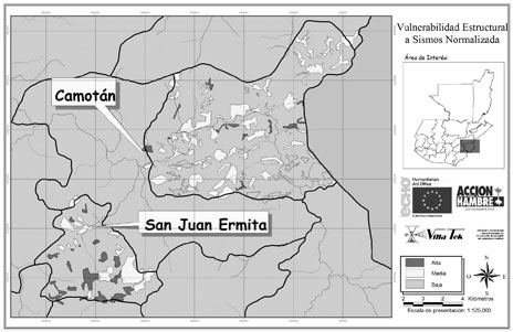
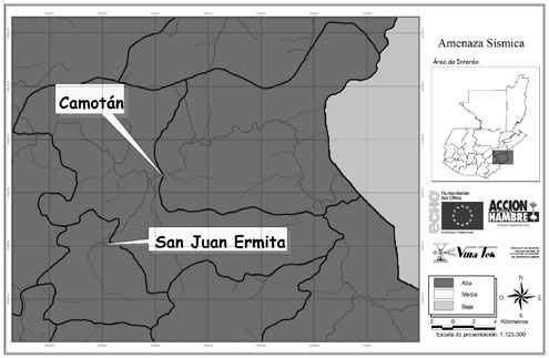
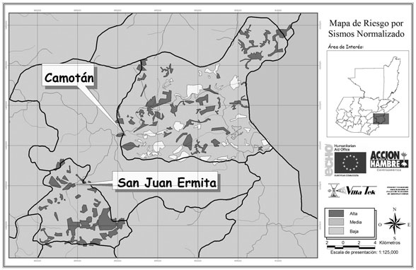
Each of these parameters is assigned numerical values agreed upon by different experts. These values range from 1, which would be the lowest vulnerability value assigned, for instance, to a straw roof in case of an earthquake, to 10, which would represent the highest vulnerability value assigned to the same roof in case of strong winds. This also considers the socioeconomic and demographic vulnerabilities of the family living in that housing, in relation to existing hazards. The following table includes the vulnerability indicators taken into consideration by this study, as well as their corresponding parameters: Information was taken from national censuses and field interviews in order to estimate the levels of existing vulnerabilities. Once vulnerability levels were established in housing located in these study areas, particular aspects of existing hazards in these regions were also analyzed. Along these lines, hazard maps were developed and superimposed on vulnerability maps previously prepared. Consequently, risk maps were developed drawing upon those vulnerability and hazard maps. For instance and as shown below, in the presence of seismic risk, vulnerability, hazard and risk maps were prepared for the municipalities of Camotán and San Juan Ermita. With the purpose of sharing the methodology applied, as well as the main conclusions of this study, the “Manual for Quantitative Risk Assessment Associated with Different Hazards” was published. This manual is intended for municipal executives and technicians, as well as for professionals involved in development projects. Community maps: a development tool During the initial risk study, in the context of the community self-assessment, we highlighted the importance of preparing community maps through a participatory process. These maps are used by community groups to visualize their community spaces and resources, the way they access these resources, and the hazards they are able to identify. This activity has also contributed to raising awareness of existing risk conditions. These community maps represent a tool that communities understand and may be used to develop proposals on prevention and mitigation measures, to be implemented by these communities in collaboration with local governments. Maps also help identify mechanisms for community self-management in order to cope with existing risks and hazards. As a result of this self-assessment, a
number of mitigation activities proposed by these communities were carried
out as examples of collective actions that may lead to vulnerability reduction:
infrastructure work (drainage systems, suspension bridges, and retaining
walls) and actions within the agricultural sector (reforestation of areas
surrounding water supply sources, introduction of techniques for forest
management, dead barriers, etc.). These actions also helped raise awareness
among the population regarding ways in which they might also contribute
to generating risk. Risk management is a multidisciplinary development approach which requires multi-stakeholders’ participation at different levels. This project involved local, national and international actors, such as the San Carlos University of Guatemala, which facilitated the participation of extension students during the community self-assessment. In addition, the Municipal Agencies for Educational Supervision and the Maya Chortí Technical Institute for Natural Resources (ITERNMACH) were represented in this project by staff members and students. The Copán Chortí Municipal Association, the Guatemalan Red Cross and Volunteer Fire Departments also participated in these activities. It is worth mentioning that the main counterpart of this project was the National Coordinating Office for Disaster Reduction (CONRED). As many local teachers and students were trained on disaster and risk issues, we were enabled to reach out to a greater number of local people and community groups. This will also produce long-term benefits, since local and academic capacity-building was strengthened. The existence of organized, trained and well-equipped groups in 50 different communities will ensure that this experience and training contents be disseminated. These groups are knowledgeable of the areas where they live, and their involvement in this project have built other local capacities to address disaster-related issues. Furthermore, people who worked directly on community organization acquired a better understanding of local dynamics. Besides the active collaboration established between all participating institutions, this project was aimed at involving local populations in order to improve their knowledge on disasters and ways to face them. The project also helped these communities organize themselves. A total of 13,500 people attended the 350 training sessions and/or meetings held throughout the life of this project. As a result, a training handbook was put together jointly with major Guatemalan organizations that, in recent years, have been working on local risk management. This user-friendly guide will be effective in disseminating knowledge and best practices for disaster prevention and response, consistent with the limitations and hindrances faced by rural communities, which represent 60% of the total Guatemalan population. The previous work done by different organizations and the use of existing awareness material were very helpful to the project, such as the posters produced by UNICEF. These posters were intended for students and included recommended actions before, during and after three hazards: earthquakes,hurricanes and floods. Also, the Regional Office of the International Strategy for Risk Reduction (ISDR) provided educational material, the ‘Riskland’ board game and a children’s publication entitled “Learning to prevent Disasters.” Some 2,000 issues were distributed in more than 50 local schools in these areas. In addition, radio programs reached an audience of approximately 28,898 people, thanks to the support provided by the most popular radio station in the Chortí region: FM Tierra. These radio programs included the drama series entitled “Times of Hurricanes” [Tiempo de Huracanes], produced jointly by the Pan-American Health Organization (PAHO) and the ISDR; the radio soap opera entitled “Threats to a Nearby Planet” [Amenazas en un Planeta Cercano]; and a series of documentaries on disasters produced by Radio Netherlands and UNESCO. Finally, a number of messages were transmitted to provide information about soil erosion, agro-forestry management techniques, forest protection, forest fire management, and prevention of and response to floods, earthquakes and landslides. With the valuable support other institutions, such as FAO-PESA, CONRED, Peace Corps, the Spanish Red Cross, Communicators without Borders, and UNICEF, images and messages related to risk and environmental management were chosen to be included in posters and brochures.The process carried out to validate this material with the communities involved led to the improvement of such material, ensuring in this manner that key message would be conveyed. In terms of training, the involvement of specialized bodies was essential, including the Maya Chortí Technical Institute for Natural Resources (ITERNMACH), through their extension students who trained children and teachers from schools located in agricultural areas. The Guatemalan Red Cross also participated by carrying out training sessions for rural teachers on psychosocial support in case of emergency situations, and school security. It is also worth mentioning the actions carried out with the National Forest Institute (INAB), which included training session on fire fighting and forest management intended for community fire brigades, which were also provided with equipment. Finally, Volunteer Fire Departments, the National Civil Police and a number of health centers benefited from training courses on risk management and emergency aid. In this context, equipment was donated for emergency situations and the Guatemalan Red Cross complemented this training with first-aid courses.
Risk management centers: a step towards autonomy Jointly with the communities of Copán and Chortí and the Municipalities of Camotán and San Juan Ermita, 15 buildings were built or renovated to be used as Risk Management Centers (CGR). These centers now render services to a rural population of 49,158 inhabitants, and are equipped with emergency kits and radio transmitters with the same frequency band used by CONRED. In addition to this goal, these CGRs facilitate other community actions, as they serve as the branches of the Rural Technical Unit. They also provide health services, and their facilities are used to hold meetings and training sessions. It is considered that the CGRs strengthen community cohesion and facilitate contribution with other sectors. In coordination with CONRED, these centers have developed a sustainable cost recovery system. After analyzing a number of options, it was decided to purchase a threshing machine and build a mill. Local families are now able to thresh maize by paying a fee of 1.00 quetzals per bag. As the agency responsible for the Risk Management Centers, CONRED manages the money collected through these activities. In this manner, the sustainable maintenance of these centers is being ensured. The communications system installed has produced a clear impact on community empowerment, especially in terms of information management. In this manner, the geographic isolation of these communities has been reduced, enabling them to quickly respond to common emergencies such as child deliveries and accidents. Thus, radio transmitters have made a significant impact on these communities, and contributed to their sustainability. Conclusions and recommendations In the context of any project, the practical application of holistic approaches to vulnerability and risk assessment becomes a difficult task. In addition, due to the lack of a chronological follow-up of vulnerability indicators, it is difficult to weight them accurately. Likewise, the use of national censuses while defining parameters may lead to a higher error margin in terms of their quantification. Although risk management is an ongoing responsibility of society at large, efforts must be focused at the local and community levels. From an institutional standpoint, it is imperative that municipalities make a greater commitment to risk management, as their decisions have the greatest impact on risk creation or its reduction. Their pivotal role as local coordinators and leaders may lead to the development of integrated projects for risk management, such as the one presented in this article. Furthermore, municipalities should devote efforts to work in coordinated manners with other agencies, and raise awareness among public officials and municipal technical staff, particularly in areas such as urban planning, infrastructure, risk prevention, awareness raising programs for the population, and warning systems, among others. It is important to avoid working in excessively large areas and where there are no actual risks, because these communities and authorities will show no or little interest in getting involved. On many occasions, the work done to raise awareness and train populations at risk is based on methodologies whose contents and processes do not reflect the cultural reality of some communities. Thus, it is necessary to incorporate broader approaches that include all major social, religious and anthropological aspects. Methods and tools used must be practical, simple, and adaptable to any changes arisen in a particular context.
|
| |
Forward
|
| © UN/ISDR |