Towards Disaster Risk Reduction in Central America
Mario Fernandez Arce, Center for Geophysical Research (CIGEFI), Disaster Research Program, University of Costa Rica
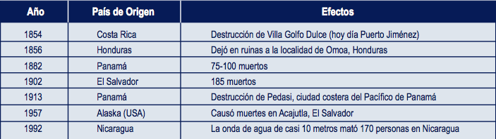
Before September 1992, Central America underestimated tsunami-related hazards, until a wave almost 10 meters high hit the Pacific Coast of Nicaragua, inundating vast stretches of land and killing 170 people. The tsunami was preceded by a slow seism only slightly perceptible to the local population, which did not realize it was in danger and was caught unaware by the destructive event. It was after this that people started studying this hazard in the region and discovered that since 1539, 49 tsunamis have hit the shores of Central America, 37 in the Pacific and 12 in the Caribbean. They have taken a toll of nearly 500 lives in the region. Local sources produce tsunamis, but they are not the only reason. Earthquakes in Alaska and Colombia have also generated tsunamis that have traveled all the way to Central America, leaving destruction and death in their wake. The following table lists the most destructive tsunamis on record in Central America.
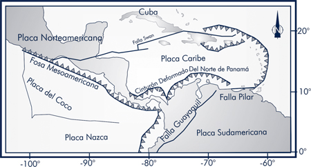
As in other parts of the world, our tsunamis are mainly caused by large earthquakes that occur under the ocean floor. They originate in four well-known geological areas: the Middle America Trench, the Panama Fracture Zone, the North Panama Deformed Belt, and the Polochic-Motagua-Chamelecón-Swan Fault System (Gulf of Honduras).
The Middle America Trench is the boundary where the Cocos plate is subducting under the Caribbean plate. The continuous collision of these tectonic plates is the primary cause of our large underwater earthquakes with the potential to cause tsunamis. But the collision of the two plates is not the only factor contributing to the generation of tsunamis. There is another element that further complicates the situation and increases their likelihood. Seamounts are being subducted completely under the Caribbean plate (mainly off the shores of Costa Rica); that is, they are not breaking up. Since they are not being destroyed, as they submerge beneath the overlying plate, they raise and deform the ocean floor, taking the shape of an underwater volcano or mountain. This increases the inclination of submarine slopes and with this, the possibility of undersea landslides that could set off tsunamis.
The area known as the Panama Fracture Zone is located at the boundary between the Cocos and Nazca plates, south of Punta Burica on the border between Panama and Costa Rica. This area is made up of a series of ruptures in the ocean floor along a north-to-south axis, where there is horizontal movement of rock blocks between the fractures. This is a very geologically active zone in which these continually moving blocks generate great tectonic force and therefore, a large number of earthquakes, all of them under the ocean. Since displacement of the ocean floor occurs horizontally, there is less potential for generating tsunamis, but even so, the zone is considered to be another source of tsunamis in the region.
The North Panama Deformed Belt is an uplifting of the seabed located off the Caribbean coast of Costa Rica and Panama. It is characterized by compressive forces and rifting both on the seabed and in the continental sector. These events suggest that the Caribbean plate is subducting underneath the coast all along this belt. Though there are not many earthquakes in this sector, they are very strong. In 1882, the biggest earthquake in Central America occurred in this area. Known as the San Blas earthquake, its magnitude was 7.9 and it was located near the San Blas Islands, to the north of the Panamanian mainland. Another strong seism along this belt was the Limon quake of 1991 (Costa Rica), with a magnitude of 7.6, as a result of the liberation of energy accumulated in one of the main faults of the system. Both earthquakes killed people and caused tsunamis.
The Polochic-Motagua-Chamelecón-Swan fault system is located at the boundary between the Caribbean and North American plates and extends along the Guatemalan-Honduran border. It cuts through Lake Izabal, enters the Gulf of Honduras and continues to southern Cuba. This system generated the tragic Guatemalan earthquake of 1976.
Vulnerability
Our vulnerability to tsunamis originated in and is intimately linked to the past, to production processes and to our development. Although the coastal regions of Central America had been inhabited by indigenous peoples since pre-Colombian times, our main coastal population centers were established in the 19th and 20th centuries to facilitate trade. Due to the historical consequences of politics, economics and social processes, a segment of Central America’s population currently lives in areas vulnerable to tsunamis. Thus, this vulnerability is the result of human social arrangements shaped by and for production processes.
But vulnerability to tsunamis is not static; it continues to accumulate and grow. Our coasts continue attracting nationals and foreigners, tourists and residents. Tourism is leading to impressive development on both coasts of our region, though especially on the Pacific. The growth of tourism on the Costa Rican Pacific is such that people now talk about certain geographical areas that are economically competitive, such as Brasilito-Papagayo and Dominical-Osa. In this first region, coastal population centers are growing, spurred on by recreational tourism, as they also are in the second region, though there the focus is more on ecological tourism. Therefore, we could say that this modern-day vulnerability stems from the level of development that has taken place, and from the lack of development planning. Dire conditions, such as poverty, the lack of resources or social exclusion are not the elements that are increasing people’s vulnerability to a tsunami-related disaster.
Vulnerability is estimated based on three components: physical exposure, resistance and resilience. The first one results from the physical location and the nature of the surrounding natural and human-made environment. Resistance is related to the capacity of an individual or a group of people to protect themselves against the impact of a hazard, and is a reflection of their physical, psychological and economic health, individually or as a group. The best efforts to increase resistance are focused on broader goals of economic, political and social inclusion. Resilience is the ability of an individual to cope with or adapt to a threatening stress, and results from planned preparedness in the face of a potential hazard, and from spontaneous, premeditated adaptation in response to a felt hazard. Below, we will analyze each of these components as they relate to a tsunami hazard.
Both coasts are exposed to tsunamis, though the Pacific coast is more so because it is right in front of the area where the Cocos and Caribbean plates are colliding, the primary source of our underwater earthquakes. This coast is also more populated than the Caribbean side. On the other hand, however, the topography of the Pacific is characterized by high elevations, making it a coastal region with many high, safe areas where refuge can be sought at the sign of a hazard. The Caribbean coast is just the opposite; there is much less seismic activity, but, in general terms, its flat landscape offers very few secure sites where people can escape from a potential tsunami.
If resistance means being able to protect oneself, and if greater resistance has to do with economic, social and political inclusion, we can conclude that we are currently as vulnerable as we ever were. In fact, our vulnerability may even have increased, since the gap between the rich and the poor appears to be growing, social change is not taking place and people do not have a voice in political decisions. We continue to be a poor region with limited rural development, dengue fever on both coasts, a high level of citizen insecurity and a growing wave of violence and crime. Given all of this, it is easy to conclude that conditions are not conducive to enhancing our resistance to hazards in our region.
The only component that is improving is resilience, basically due to the education offered to students and coastal residents.
Disaster risk reduction in Costa Rica
Disaster risk is a convolution of hazards, as a result of vulnerabilities. Both hazard and vulnerability coexist and are mutually dependent. This means that there is no vulnerability if there is no hazard, and there is no hazard if one is not exposed or vulnerable. Given that there is a hazard of tsunamis and vulnerability to them in Central America, there is also risk. And if there is risk, measures must be taken to reduce the potential losses to the people and systems that are exposed to such hazards. Disaster risk reduction involves three public policies: risk identification, risk reduction, and disaster management.
Risk identification
Individual perception, society’s interpretation, and the objective estimation of risk factors —hazard and vulnerability—, all play an important role in this aspect. Before the 2004 tsunami in Indonesia, practically no one in Central America knew what a tsunami was, both because they do not occur regularly and because they do not cause disasters very frequently. As a result, they were not perceived of as being a hazard. Therefore, people did not usually see them as an element in their surroundings and did not have an image or understanding of them. However, the situation changed with the events of 2004, when pictures of the great tsunami and its tragic outcome were seen in almost every corner of the world. People’s attitudes shifted from incredulity and denial to perception and acceptance of the risk. Now, a large number of Central Americans think that tsunamis are big waves that are usually destructive. There is greater awareness of the issue and people are more willing to consider making changes to ensure preparedness and mitigation efforts. However, some members of society still show signs of indifference, lack of interest and skepticism.
The estimation of risk factors has been previously addressed (Fernández et al., 2000; Fernández and Rojas, 2000; von Huene and Ranero, 2000; Fernández, 2001; Fernández and Alvarado, 2005; and Fernández and Ortiz, 2007) and is supplemented by this article. There is a real possibility of local tsunamis on both coasts. More detailed studies need to be done, including the potential for inundation, in order to understand the hazard and vulnerability of a specific area. In Puntarenas, the main Pacific port in Costa Rica, preliminary estimates have been done regarding tsunami inundation.
Risk reduction
Risk reduction includes prevention and mitigation measures. Prevention begins with doing research about a hazard and identifying the existing vulnerability. The ongoing study of hazards, their effects and the dynamic interactions among these and people’s livelihoods and the welfare of societies continue to be a fundamental element of effective disaster risk reduction strategies. Thanks to efforts being made by different programs at the University of Costa Rica (the Geophysics Research Center, the Disaster Research Center, the National Seismological Network—RSN: ICE-UCR), it has been possible to substantially improve knowledge about tsunami-related hazards in the region. Research studies have looked at the historical record of these events, future possibilities of tsunamis occurring, and their potential impact on society, as well as the social, economic and environmental implications of our vulnerability to tsunamis. These studies have confirmed that our two coasts do show a potential hazard and the likelihood of future events. In addition, studies of the ocean floor reveal that the continental shelf is extremely deformed by seamounts subducting underneath the Caribbean plate, which is creating instability that is prime for causing rapid movements of masses of water that could result in tsunamis.
With regard to prevention, serious, active efforts are being made in the areas of education and outreach. Recognizing that the region is exposed to tsunami-related hazards, the issue needs to be addressed through regional, national and local institutional efforts. In this context, education is taking on importance as a means for disseminating information, increasing knowledge, changing attitudes and fostering good practices in the medium and long term. This was the motivation for the design and implementation of the project titled School Outreach in the Face of Tsunami Hazards in Puntarenas’ Central District, Costa Rica, a joint effort of the National Emergency Committee, the Ministry of Public Education, the San José Municipal Government, the Japanese International Cooperation Agency (JICA), and the University of Costa Rica. This project marks the start of a process that includes information and knowledge about good practices, as well as training, prevention and response activities.
The social impact of the project will stem from 230 teachers, who will receive basic information that they will then teach to their students. Children will also be provided with appropriate educational materials, so that they can teach their families about tsunamis. This is a pilot project that will be replicated in all the coastal areas of the country.
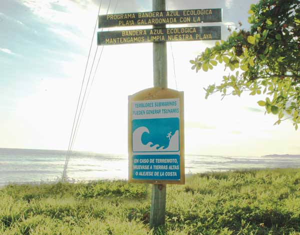
Closely tied to education is the installation of signs on beaches. This effort has already begun in Costa Rica, with the sponsorship of private companies. The first of these warning signs was installed by the Marriott Los Sueños Hotel. Two signs were put up, one in Spanish and one in English, keeping tourists in mind. A sign was also put up at Bejuco Beach, near the University of Costa Rica. As part of the Puntarenas tsunami risk project, more signs will be put on the beaches of this province.
Regarding mitigation, which is more related to construction methods, it is important to point out that buildings near the beach should be strong enough to withstand being hit by the mass of water from a tsunami. Some buildings could partially collapse if hit by a huge mass of water. Tourist developments should be built on higher grounds to reduce the risk of being inundated.
Works cited
Fernández, M., Molina, E., Havskov, J., Atakan, K., 2000: Tsunamis and tsunami hazard in Central America. Natural Hazards 22: 91-116.
Fernández, M., Rojas, W.,2000: Amenaza sísmica y por tsunamis, in: Denyer, P., Kussmaul, S.(Eds), Geología de Costa. Editorial Tecnológica de Costa Rica.
Fernández, M., 2001: Daños, efectos y amenaza de tsunamis en América Central. Rev. Geol. AMER. Central, 26: 71-83.
Fernández, M., Alvarado, G., 2005: Tsunamis and tsunami prepardness in Costa Rica, Central America. ISET Journal of Earthquake Technology, Paper 466, Vol. 42, No. 4, pp 203-212.
Fernández, M., Ortiz, M.,:.Earthquake-Triggered Tsunamis in Central America, in: Bundschuh, J. & Alvarado, G.,: Central America: Geology, Resources and Hazards, Taylor & Francis,
|