Latin America and the Caribbean
|
|
| International
Strategy for Disaster Reduction Latin America and the Caribbean |
Newsletter
ISDR Inform - Latin America and the Caribbean |
 |
|
Partners
in action
|
|
|
Forward
|
|
Multinational Andean Project:
Geoscience for Andean Communities Strengthening
Geoscience Knowledge in Communities
 On
June 28, 2002 the Canadian International Development Agency (CIDA) approved
CDN $12,000,000 as the Canadian counterpart contribution to a 6 year geological
hazard project managed by the national geoscience agencies of Argentina,
Bolivia, Chile, Colombia, Ecuador, Peru, Venezuela, and Canada. After
just over one year in operation the Multinational Andean Project: Geoscience
for Andean Communities (MAP:GAC), has counted collaboration with the UN/ISDR
as one of its successes. On
June 28, 2002 the Canadian International Development Agency (CIDA) approved
CDN $12,000,000 as the Canadian counterpart contribution to a 6 year geological
hazard project managed by the national geoscience agencies of Argentina,
Bolivia, Chile, Colombia, Ecuador, Peru, Venezuela, and Canada. After
just over one year in operation the Multinational Andean Project: Geoscience
for Andean Communities (MAP:GAC), has counted collaboration with the UN/ISDR
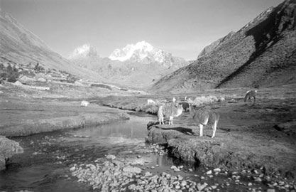
as one of its successes. The Andes mountains are recognized as one of the regions on earth most susceptible to natural disasters of geological origin. It is one of the most volcanically active regions on earth and boasts the record for the earthquake of highest magnitude ever recorded instrumentally (Chile Magnitude 9.5 in 1960). This region also sees frequent devastating slope failures (Vargas, Venezuela in 1999) as well as smaller events that damage infrastructure costing countries millions of dollars annually. Having begun discussion on the possibility of undertaking a geological hazard project in 2000 near the conclusion of another CIDA sponsored project, the member countries expressed the need within their countries and within the region to promote high quality scientific investigations into natural hazards, the integration of that information across institutions and the application of the knowledge at the community level. They decided the project goal should be to contribute to improving the lives of peoples of the Andes by providing high quality , geoscience and geospatial information for use in land-use planning and geological hazard mitigation. As the focus is on geological hazards (landslides, earthquakes, and volcanoes), the national geoscience agencies of each country were selected as the managing agencies. Project activities are aimed at strengthening the capacities of the participant institutions mainly through training and collaborative work. There is also a large component of the project that focuses on integration with other national and international institutions and organizations interested in the goals of the project. Project activities include workshops on new techniques in geoscience, information technology, and communication with communities, as well as field courses, production of joint regional products and development of new technologies and regional standards. In each member-country project work is based in one or two specific geographic areas in which either human life or infrastructure is vulnerable to a geological hazard. When choosing the project regions, emphasis was put on selecting areas along borders as this encourages cross-border integration of scientific data and collaboration on common scientific problems. One project objective is to ensure that geological hazard products generated by the national geoscience agencies are relevant and understandable to the various communities affected by the hazard being studied. To achieve this, the project has developed a community communications component under which closer contact and collaboration with various institutions and communities is being undertaken by the member countries in an effort to learn what knowledge is required and how it should be presented to the various groups. In particular, MAP:GAC members plan to work with organizations involved in planning, emergency management, as well as organizations working on the evaluation of vulnerability, and the actual communities affected by hazards in an effort to help them appropriate and apply the geoscience knowledge produced. Early in the project design phase it was realized that integration of digital scientific databases would be necessary to facilitate the transfer of data between scientists, institutions, and communities. In response to this it was decided to adopt Geological Survey of Canada (GSC) developed technology and enhance it to meet member-country needs. Thus was born GeoSemantica, a web interface that allows for the transfer and unification of standardised data between databases and thus between institutions. Communication of scientific knowledge to other communities requires care and attention and so does communication between scientists. In order to create standards for joint publications as well as for digital data exchange it is necessary that all participants agree on terminology and definitions. In March of this year, the project steering committee, the Executive Council (which meets twice per year), agreed to adopt "Living With Risk" as a reference document and to work in conjunction with UN/ISDR on the Spanish translation of risk-related terminology. In June, Dr. Pedro Basabe of UN/ISDR attended the first meeting of MAP:GAC Geoscience Working Group in Santiago, Chile to collaborate on creating definitions acceptable to all participant countries. The project has now taken the important first steps toward standardising the terminology that will be used in the project, including the creation of metadata for GeoSemantica.
Communication of project activities and advances are key to the success of a project of this size and scope. To this end the project maintains a bilingual (English and Spanish) website (www.pma-map.com/gac), as well as a monthly newsletter (MAP:GAC News or Boletin PMA:GCA) which is published in both English and Spanish and all back issues area available on the project website. Having
recently celebrated one year as a project, the MAP:GAC Executive Council
is aware that success requires dedication of all participants and a recognition
that as geoscience institutions they cannot do it alone. The UN/ISDR,
because of its mandate and institutional experience, has provided invaluable
help and guidance. It is certain collaboration with UN/ISDR, will help
MAP:GAC achieve its desired goal of aiding communities of the Andes in
becoming safer and more disaster resistant. |
|
|
Forward
|
| © UN/ISDR |