Latin America and the Caribbean
|
|
| International
Strategy for Disaster Reduction Latin America and the Caribbean |
Newsletter
ISDR Inform - Latin America and the Caribbean |
 |
|
Partners
in action
|
|
|
Forward
|
|
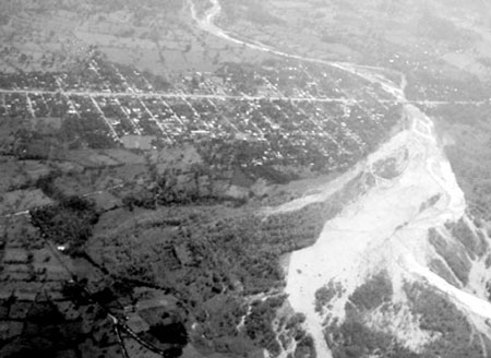
Implementing Early Warning Systems in Atlantida, Honduras
By Dr. Juan Carlos Villagrán
De León
Since
1994, a number of institutions such as the Permanent Contingency Commission
(COPECO), the Organization of American States (OAS), and the German Agency
for Technical Cooperation (GTZ) have established community-based early
warning systems in watersheds that originate in the Nombre de Dios Mountain
Range and flow into the Caribbean Sea. As community-based systems, these
models rely on the work done by volunteers located in different places
along the watersheds. These volunteers carry out all activities associated
with the systems, from monitoring to response-related actions. During
2003, VILLATEK implemented for COPECO and UNDP-Honduras early warning
systems in the Lean, Cangrejal, Perla and San Juan watersheds. The design
of each system was based upon geo-morphologic and hydrologic studies conducted
in these watersheds.
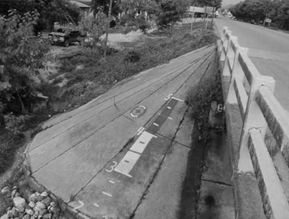
Morphologic studies characterized the structure of the watersheds by using the basic principles of the Horton’s Analysis. In addition, hydrologic studies were initiated with statistical analyses of rainfall in La Ceiba and Tela which, subsequently, were used to design these early warning systems. Developed by the US Army Corps of Engineers, HEC-HMS and HEC-RAS software was used to conduct the hydrologic studies. Hydrograms –which reflect how the water flow behaves in a given period of time and within a specific area of the watershed- allowed identification of the places most prone to overflowing. The National Meteorological Service provided data on rainfall, used to supply the models of each watershed. The adjustment of models was carried out using data obtained from each of these watersheds, as well as the time when the volume of water is at highest in different points of the lower watershed. Information gathered from these hydrologic models allowed for the design of technical aspects related to the operation of early warning systems. Once the technical designs were finalized, these systems were implemented with the technical support of staff members from COPECO’s regional office in La Ceiba, as well as volunteers in each watershed and officials responsible for municipal early warning programs. How these systems operate In all these systems, rainfall, river levels and existing hydro-meteorological conditions are monitored on a regular basis. Rainfall is measured using TruCheck plastic rain gauges. River levels are measured by using scales painted on bridges or using electronic devices designed and built by VILLATEK, S.A. Lastly, weather conditions are assessed using meteorological stations developed by OREGON SCIENTIFIC. All individuals working on each system were trained in using these devices, and databases were set up in each mayoral office to gather information reported by the operators. Forecasting is done through simple protocols that take into consideration accumulated rainfall in six-hour periods and river levels. Yellow or red warnings are issued when monitors at bridge stations indicate that river levels have reached the yellow or red areas respectively. In such case, the monitor reports this to the corresponding Mayoral office, and includes which level the river has overflowed. The Municipal Council, then, requests authorization from COPECO’s regional office in La Ceiba to issue the respective warning (yellow or red) to populations that may be affected. After receiving the warning, communities put into practice a number of actions included in their emergency plans, such as the launching of the Emergency Operations Center, the search and rescue, evacuation and shelter commissions, and/or other similar bodies. As with other community-based early warning systems in Central America, information is transmitted through a network of radio-communications that links all stations along the watershed. All radios have a 12-volt energy source and batteries to operate even in critical cases when there is no power. An essential part of these systems was developed during a number of drills. These exercises were an opportunity to find some critical problems in plans already in place, in order to improve them. Lessons learned Community-based early warning systems are enabled to forecast flooding in plain areas, and coordinate appropriate responses with COPECO’s regional office. Along these lines, it is worth mentioning the following lessons learned to date: • Voluntaries
in watersheds do reliable work. • Communities
have also used radio communication to solve social problems, such as
addressing the need to have medical assistance, requesting ambulances,
and asking for and exchanging information about the weather in nearby
watersheds.
Proposed maintenance for these systems The following strategy has been developed in order to maintain these systems: • Volunteer
operators and Mayoral offices are responsible for the functioning of
these systems. For this reason, a procedure has been established for
requesting information and recording it in a logbook per station several
times a day, in order to identify the status of these stations at all
times. Conclusions Community-based systems implemented along the northern coast have proven to be functional based on strategies previously planned. Although the change of personnel in Mayoral offices due to electoral processes have brought about some problems, volunteers from more than fifty communities have shown their willingness to operate these systems and use them in different ways. This positive result in Honduras has also been observed in other Central American countries, in which similar systems have been put in place.
|
| |
Forward
|
| © UN/ISDR |