Latin America and the Caribbean
|
|
| International
Strategy for Disaster Reduction Latin America and the Caribbean |
Newsletter
ISDR Inform - Latin America and the Caribbean |
 |
|
Disaster in the Region
|
|
|
Forward
|
|
Remembering
The Worst Earthquake In Latin America:
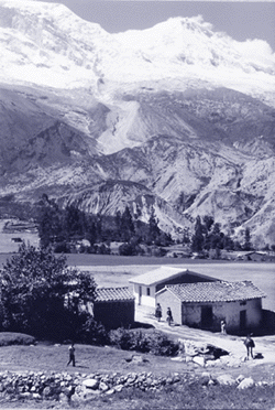
The Apus, ancestral gods of the Andean peoples, were not just symbolized but rendered physical by their tutelary mountains. Huascarán—at 6,768 m above sea level, the tallest mountain in Peru—was the tutelary god of the Ancash people. Its majesty and power made them feel secure. But on 31 May 1970, its force was destructive rather than protective, unleashing the worst seismic catastrophe even experienced south of the Rio Grande. For a society predisposed to forget its own history, it is always useful to be reminded of the consequences of natural disasters, especially when they are so devastating that they cry out for a more effective response than relief and reconstruction alone. The earthquake that hit Northeastern Peru three decades ago can still teach us valuable lessons, including the need to monitor carefully governments’ disaster reduction policies and their effectiveness, and try to promote a culture of prevention throughout all sectors of society. Geologically, Peru has a seismically active continental margin with an Andean-type structure, including three multiple-channel seismic traverses between 5°S and 12°S, located off the coast near the towns of Paita, Chimbote, and Huacho. The findings of the Nazca Plate Project (1972-1980) revealed that the continental metamorphic rocks extend at least as far as the continental shelf, and sediments have accumulated along the lower shelf slope in front of Chimbote and Huarmey, between 9.5°S and 11.5°S, in the Department (State) of Ancash. In 1970, an earthquake between 7.6 and 7.8 magnitude on the Richter scale took place; its epicenter was 30 Km away from the coast, where the Nazca Plate is being subducted by the South American Plate. This causes frequent earthquakes, due to its location between the Mendaña Fault and the Nazca Dorsal, in the central region of Peru. It is there that the most earthquakes, of the most severe magnitude and intensity, have shaken the country, causing the greatest loss of life and property. The 150 Km epicentral radius hit the cities of Huaraz, Caraz, and Aija, in the Huaylas Corridor, located in the Andean area of the Department of Ancash, partially destroying these towns while others—including Trujillo, the third largest city in Peru, as well as Chimbote and Casma—suffered considerable damage.
In Chimbote, 75% of homes were damaged; 96% of the adobe houses were destroyed. More than 1,000 people died. The worst damage, however, was the result of avalanches, which had already ravaged the Santa Valley in the Andes eight times in the previous 30 years. In 1962, for instance, 4,000 peo-ple died in the city of Ranrahirca due to these events. The earthquake that hit the departments of Ancash and sou-thern La Libertad in 1970 prompted a catastrophic glacial drift that destroyed the town of Yungay in the Huaylas corri-dor. A mass of ice between 5,500 and 6,000 m above sea level in the Huas-carán, slid down 10 Km. The avalanche reached the cities of Yungay and Ranra-hirca in a mere three minutes. In Ranra-hirca, 1,800 died. In Yungay, 17,000 died under the ice. Ironi-cally, many of them had been evacuated and sheltered in the church of Yungay. Only 400 survived, including the geo-physicist Mateo Casaverde, current advisor to the National Civil Defense Institute (INDECI) and tenured professor of the School of Civil Defense of Trujillo National University. The avalanche reached the slopes of the opposite side of the Santa Valley to a height of 83 m. Three layers 10 m thick of soil and sand covered an 8 Km2 area. The total volume of the ice and soil that thundered down was between 50 and 100 million tons. The government of Peru has forbidden the excavation of the area where the city of Yungay was buried, declaring it a national cemetery. The few survivors were resettled. The tragedy inspired the government in 2000 to declare 31 May, Natural Disaster Education and Reflection Day, in memory of the deadliest seismic disaster in the history of Latin America.
For more information,
please contact: ______________________ |
|
|
Forward
|
| © UN/ISDR |