Latin America and the Caribbean
|
|
| International
Strategy for Disaster Reduction Latin America and the Caribbean |
Newsletter
ISDR Inform - Latin America and the Caribbean |
 |
|
Socios
en Acción
|
|
|
Forward
|
|
Antofagasta,
Chile, and the threat of tsunamis
Antofagasta is taking responsibility for its own risks. Since the late 1990s, it has been carrying out technical hazard assessments that decision-makers can use to promote the safety and welfare of local residents and their assets. This mining town, which contributes a third of Chile’s gross domestic product (GDP), was struck in the early nineties by two natural disasters that killed 117 people and caused extensive economic losses. The key lesson that was learned then was how few resources were available to confront emergencies in the area. The 1991 flash flood, for instance, brought attention to the fact that 17 flood-prone brooks crisscross the city from North to South. The 1995 earthquake, meanwhile, met with an inadequate response as the authorities took several hours to determine whether evacuation of the coastal zone was necessary, causing public confusion and panic in the face of the event, which measures 7.3 on the Richter scale. In the aftermath of these disasters, the potential contribution of local universities to risk management and mitigation began to be taken seriously. In tandem with international experts, technical and scientific research was carried out to assess the vulnerabilities of the 320,000 inhabitants. Beyond a doubt, two projects contributed significantly to the emergence of an integrated community approach to disaster prevention. One of them was the RADIUS project, carried out between 1997 and 1999. The other was the Global Earthquake Safety Initiative (GESI), executed in 2000 and 2001. Both projects were carried out with the support of the United Nations and the cooperation of local and foreign experts. These projects helped establish and consolidate the local Emergency Committee, which brings together scientists, members of the Armed Forces and the Police, and representatives of the regional and municipal governments. The Committee examined the various assessments and, based on the flood risk maps produced by the Hydrological and Oceanographic Service of the Chilean Navy, established a Tsunami Safety Line. This Line and several changes to the General Urban Development and Building Code and the Antofagasta Regulatory Plan were initiatives that had been suggested in the RADIUS action plan, given the lack of preparedness to an eventual disaster of this kind. The Tsunami Safety Line One of the natural phenomena that causes the most concern in Antofagasta is tsunami, particularly since Chile is part of the “Pacific Fire Belt” where between 60 percent and 70 percent of all tsunamis take place. The accelerated growth and coastal urban development that Antofagasta has experienced in the last decade makes the potential for such a disaster an even grimmer prospect. Based on several wave-flooding statistics and the magnitude of the earthquakes that have produced them, this city is more vulnerable to tsunamis in its Southern and South-Central areas, away from the harbour and bay that are protected geographically by Tetas Point. The worst tsunamis
that have ever occurred in Northern Chile were caused by seismic events
with epicentres close to the coast. The most severe from which historical
records exist took place in 1877.
In recent years, efforts by the Municipal government and the Emergency Committee have focused on the disaster reduction components of the Antofagasta Community Development Plan, which encourages greater participation, cooperation and responsibility by the community and public and private bodies in improving the quality of life of the city’s residents, particularly those who are less well off. The new Antofagasta
Regulatory Plan, drawn up by the local municipality, dedicated an entire
chapter to the issue of safety from the risk of natural disasters, turning
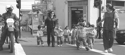
Antofagasta into the first Chilean city to regulate on this matter. By including in the new Regulatory Plan hazard-prone areas, such as places vulnerable to tsunamis, other floods, landslides and earthquakes, special attention can be paid to their prevention, including the use of zoning to determine what can be built where. Evacuation drill After the Tsunami Safety Line was drawn, the Municipality carried out a school evacuation drill in the central coastal area of the city involving the participation of more than 2,000 pre-school, primary and secondary school students. The exercise uncovered mistakes and gaps that can be corrected through improved prevention and emergency response training. “While some children| sought shelter under their desks,” says Marcelo Cifuentes, “others ran downstairs and through the streets. No accidents occurred, which shows that the work carried out by the Municipal Social Development Corporation, in charge of municipal schools, is producing excellent results, in addition to awakening the interest of the students themselves in the issue of natural hazards.” An earlier evacuation drill carried out in the same sector in 1999 as part of the RADIUS project lasted 14 minutes and involved 16 schools located in the tsunami danger zone. The one carried out this year on 10 October, national Civil Defence Day, required only 12 minutes, which the Municipality considers a good improvement. however, newer and more frequent drills should improve the evacuation procedures even more, particularly in those schools located in the areas most at risk. The evacuation drill was carried out for two reasons, say its organizers. The first, and most important, was to test the emergency response plans of the schools located in the high-risk areas, where the Municipal Social Development Corporation works closely with the security officials of each school in order to raise the awareness of the students, familiarize them with the risks they face, and show them how to respond. Secondly, it enabled the organizers to celebrate Civil Defence Day with an activity that involved the effective participation of over 2,000 students, police officers, fire-fighters and other rescue workers. In the coming months, the Municipal Government is planning additional drills involving not only schools but also public facilities and homes in the areas most prone to disasters due to both their geographical conditions and their socioeconomic condition. “This is our
way of assessing … the deficiencies that still remain and the work
we are carrying out to correct them,” says the Mayor. The process of risk management and mitigation in Antofagasta, which began with the carrying out of several assessments and changes to the local Regulatory Plan, as well as the drawing up of the Tsunami Safety Line and an increasing number of evacuation drills, is part of an ongoing municipal commitment to improve the quality of life of residents. Araya, who has for the past 10 years headed the municipal government of Chile’s fifth largest city and the country’s mining capital, explains: “All the works that the Municipality undertakes are always guided by this concept. This goes well beyond educating, preventing, and carrying out simulations. The challenge is to enjoy a safe community in which all of our departments participate and interact effectively.” At present, the major challenge is to prevent the accelerated process of growth, development and modernization from getting out of control. It is here that planning emerges as the key tool, among the development policies promoted by the Antofagasta local government, to reduce the risk of loss of life and property in the event of a natural or man-made disaster. Cinthia Rojas
Castillo and Gloria Paredes Li-Yau are professional journalists who participated
int eh RADIUS and GESI projects in Antofagasta. Sources: Informe Técnico
Proyecto RADIUS – Antofagasta (1998-1999). Northern Catholic University,
Regional Emergency Bureau, GeoHazards International and Secretariat of
the International Decade for Natural Disaster Reduction (IDNDR). |
|
|
Forward
|
| © UN/ISDR |