Latin America and the Caribbean
|
|
| International
Strategy for Disaster Reduction Latin America and the Caribbean |
Newsletter
ISDR Inform - Latin America and the Caribbean |
 |
|
In the Spotlight: Moutain
Areas
|
|
|
Forward
|
|
The
Andean Corridor: Intervention Strategies and Policies for Risk Reduction
and Sustainable Development
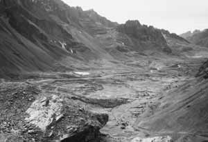
As the spinal column of the continental divide, the Andes offer very few East-West passages, increasing both the risks and the costs of trade. Other than Chile, which lies west of the mountain rage, Southern Cone countries have historically tended to ship their exports from the Atlantic—which was satisfactory only when Europe and Eastern North America were their main markets. Incorporating the Andes into the regional development process is thus a strategic political and economic objective for ensuring the development of MERCOSUR, given the importance of Pacific Rim markets. With the launch of
MERCOSUR, the most accessible East-West passages became true bottlenecks,
very difficult to manage due to the rapid increase of overland shipping2
and the inability of the regional alliance to build the infrastructure
and provide the maintenance needed to counter Nature’s hostility
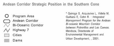
in the dangerous mountain passes. At present, most East-West MERCOSUR trade—70%—goes through what is called the Central Bi-oceanic Corridor. Its Andean section, called the Andean Corridor or the Cristo Redentor-Libertadores Corridor, links the north of Mendoza Province, Argentina, with the Valparaiso region of Chile. It is the only mountain pass with the infrastructure and services needed to handle such trade volume, and is of strategic importance for the flow of goods and services between the Atlantic and the Pacific. In such circumstances,
land use management and risk management policies play a key role in reducing
marginal costs and risks and improving the safety and reliability of the
Corridor. Improving the infrastructure of the Andean Corridor and adopting newer and more effective technologies, indispensable tasks for ensuring the competitiveness of the Andean trading block, have become the joint responsibility of the governments of the Chilean Fifth Region (Valparaiso), the Metropolitan Region of Chile, the Argentinean federal government and Mendoza province, with a strong role by private companies that see the Corridor as a key growth opportunity.
In this context, the Ministry of the Environment and Public Works of Argentina, through the Environmental Management and Urban Development Directorate of the Under-secretariat for the Environment, agreed upon an action plan based on the following goals:
In parallel, the Ministry launched an Andean Corridor Land Use and Risk Management Project. The plan is currently under development and will cover the section between Álvarez Condarco and Las Cuevas in Argentinean territory. The Project includes specific sub-projects aimed at promoting the development of the area, reducing costs, increasing safety margins and reducing the risk of natural disasters. The overall goal is to ensure the coordinated and efficient management of resources to guarantee the sustainability of the Corridor and its trade in the new international context. The sub-project are the following: • Land use management
of the Potrerillos-Cacheuta-Álvarez Condarco section. As well, the government of Mendoza has begun intensely coordinating its actions with those of the government of the Fifth Region of Chile through bilateral protocols. For more information,
please contact:
|
|||||
|
|
Forward
|
| © UN/ISDR |
 MERCOSUR,
the economic union of the Southern Cone countries that began in 1995,1
faces among many other challenges the need to find cost-effective ways
of using Chile’s Pacific Ocean ports as a link to East Asia and the
Western ports of the North American Free Trade Agreement (NAFTA) countries.
But the geomorphologic structure of South America conspires against this
objective.
MERCOSUR,
the economic union of the Southern Cone countries that began in 1995,1
faces among many other challenges the need to find cost-effective ways
of using Chile’s Pacific Ocean ports as a link to East Asia and the
Western ports of the North American Free Trade Agreement (NAFTA) countries.
But the geomorphologic structure of South America conspires against this
objective. 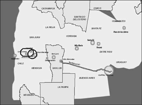
 The
Andean Corridor experience has once again taught us the lesson that
the environmental fragility of high mountain regions in the face
of human habitation calls for the greatest creativity and control
over the environmental processes unleashed by society, particularly
when they involve highly dynamic economic activities such as the
transport of merchandise aimed at international markets.
The
Andean Corridor experience has once again taught us the lesson that
the environmental fragility of high mountain regions in the face
of human habitation calls for the greatest creativity and control
over the environmental processes unleashed by society, particularly
when they involve highly dynamic economic activities such as the
transport of merchandise aimed at international markets.